


A more typical summer-like forecast is in the cards for Acadiana this week with rain chances lower as compared with this past weekend.
In the near term, after a relatively quiet day , we have been watching hefty storms in eastern Texas spanning into Northern Louisiana Monday afternoon.
These storms should gradually weaken into the evening hours but could certainly clip the northern Acadiana parishes primarily before midnight.

Rain chances this evening will be near 20% for most of Acadiana but will likely be closer to 50% from the I-10 corridor northward into our northern parishes.
After midnight, partly cloudy, warm and quite humid conditions are anticipated with temperatures by morning in the mid-upper 70s...some 5 degrees above normal.
Tuesday should bring another partly to at times mostly cloudy day, but with enough intervals of sunshine to push our temperatures into the upper 80s.
Heat indices, like Monday, will be in the mid-upper 90s.

There may be a few "pop-up" showers or thundershowers in the area mainly from mid-morning into the afternoon hours Tuesday with rain chances closer to the 20-30% range.
An upper level trough will drop southward into the region Wednesday which should lead to a better chance (40% or better) of scattered showers and thunderstorms.
Thereafter, it appears a bit drier toward the end of the week with rain chances closer to 10% for Thursday and Friday.
Temperatures this week will continue mostly in the upper 80s but 90° cannot be ruled out any day now.
Interestingly enough, due to our very wet and cloudy pattern dating back to April Lafayette has yet to hit 90°...which is our normal high for this time of year.
In fact, right now we're sitting at the 4th latest on record to reach 90°...the latest being June 17, 1919.
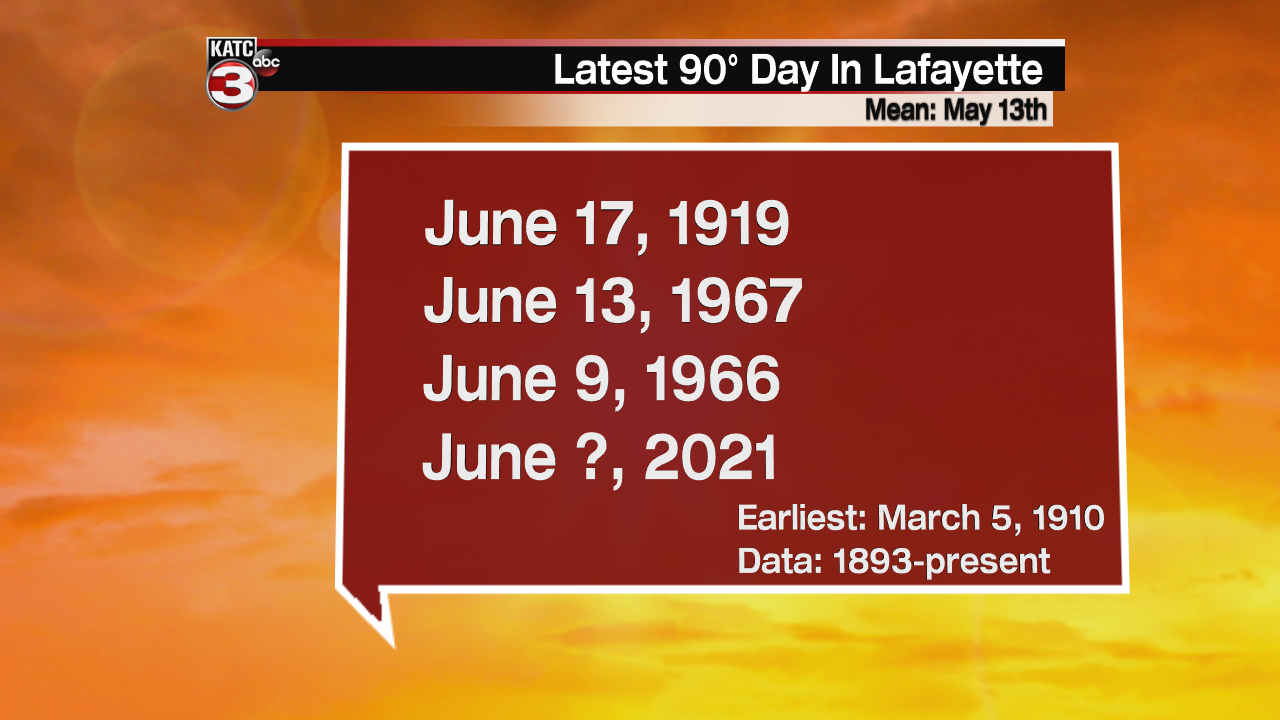
But the numbers can be misleading, our overnight lows have been near normal and have crept to above normal in the last week, so overall our mean temperatures (highs and lows averaged) are right near normal.
Moving into the weekend, rain chances may perk up again by Sunday as another upper level trough approaches the area.
See the KATC 10 Day Forecast for the latest.
Meanwhile in the tropics, the National Hurricane Center is keeping a low chance of development of a possible system that could organize by Central America into this weekend.

Long range models continue to hint something may be up by the Yucatan or Southern Gulf of Mexico sometime early next week.
No worries locally for now...we'll just keep an eye on what if anything should develop here, as we always do in tropical season.
------------------------------------------------------------
Stay in touch with us anytime, anywhere.
To reach the newsroom or report a typo/correction, click HERE.
Sign up for newsletters emailed to your inbox. Select from these options: Breaking News, Evening News Headlines, Latest COVID-19 Headlines, Morning News Headlines, Special Offers
