


After a windy and potentially stormy Monday evening, Acadiana will be in store for a stretch of some nice spring weather.
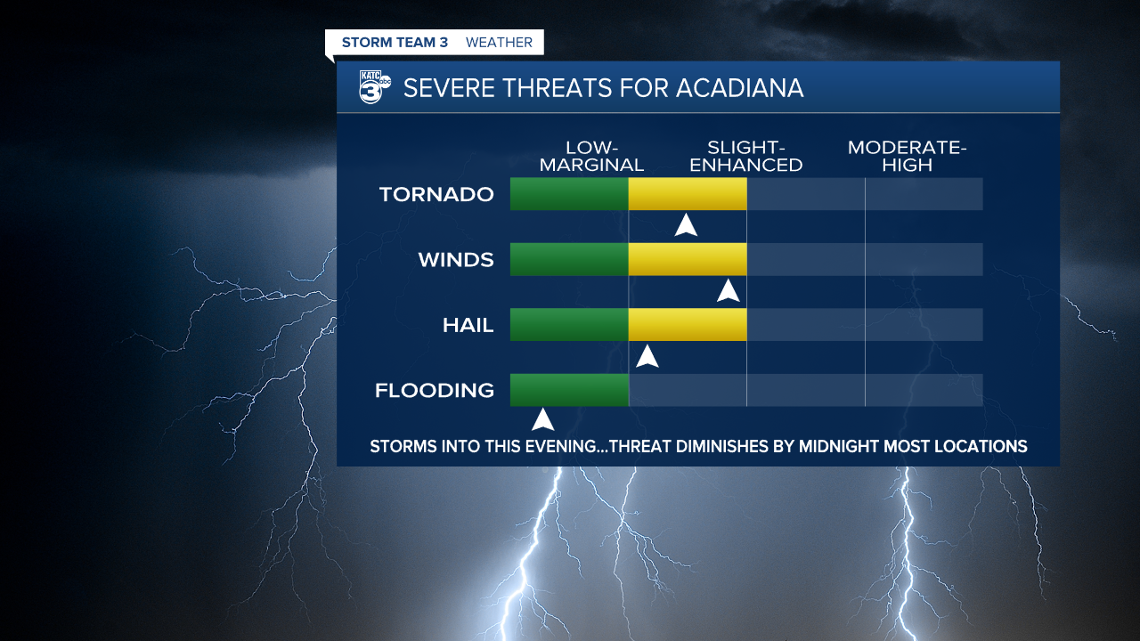
In the near term, there remains a severe weather threat for most of Acadiana's parishes probably through midnight, with the threat along with the rains moving out overnight.


The Storm Prediction Center has all of Acadiana hatched in for a "slight risk" (level 2/5) for severe storms into early Monday night, with a more substantial "enhanced risk" (level 3/5) for the northern-most portions of our area.
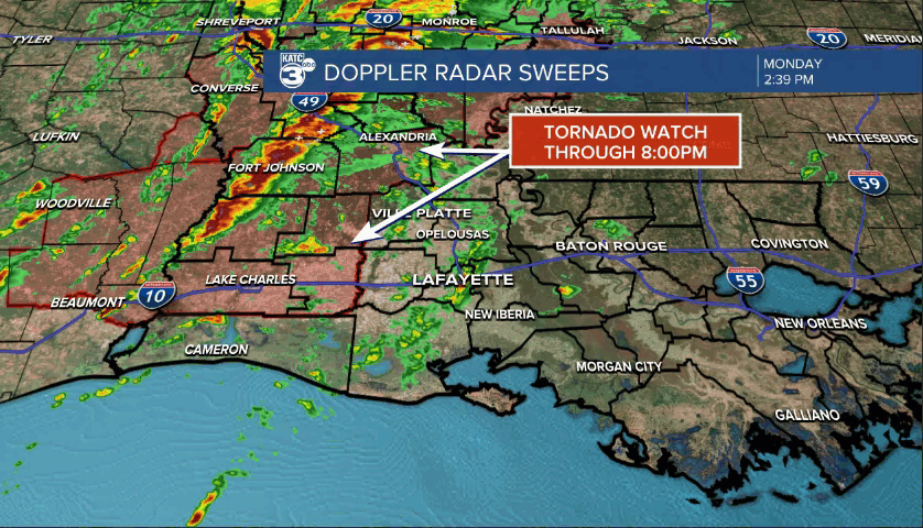
As of mid-afternoon, a Tornado Watch was in effect through 8:00 pm for the western parishes of the area and state...additional watches will probably be issued for portions of the area after 8:00 pm.
Some storms will be capable of producing strong and gusty winds to 40-50 mph, with isolated severe storms capable of greater than 60 mph winds along with a threat of one or two isolated tornadoes...especially from Evangeline/St Landry Parishes on northward.
Some storms may also contain some small hail with brief intense downpours.
Flooding is not a concern as individual storms will be hauling from south to north in the 50 mph range...while the whole line of activity moves eastward at 10-15 mph.

Rain totals of 1/2-1" or less is expected for the area with a few spots possibly catching up to 1-2".
And even away from the most intense storms, winds will remain robust with gusts to 40mph+ likely for many areas into this evening...those winds will diminish after within an hour or two after the storminess passes through the area.

The severe weather threat will begin to end from west to east around midnight (earlier to the west...later to the east) with conditions all quiet toward daybreak Tuesday.
Thereafter, other than some clouds from time to time, Acadiana will be treated to a nice, quiet and dry stretch of spring weather for the rest of the week and into the weekend.
High temperatures will warm into the lower 80s by this weekend and could push the mid-80s next week before the next front arrives mid-week.
See the KATC 10 Day Forecast for the latest, and follow KATC this Monday evening should severe storms break out across the area.
------------------------------------------------------------
Stay in touch with us anytime, anywhere.
To reach the newsroom or report a typo/correction, click HERE.
Sign up for newsletters emailed to your inbox. Select from these options: Breaking News, Evening News Headlines, Latest COVID-19 Headlines, Morning News Headlines, Special Offers
