


Acadiana's weather will be milder than normal through the end of the week with rain chances ramping up into Friday.
An increasingly more active pattern aloft combined with a waffling frontal boundary across the state will support mostly cloudy skies into the weekend along with best rain chances arriving Friday as the front drops toward the coast.

Moist southwesterly winds will continue to usher in damp Gulf humidity with some areas of fog that have been persisting along the Southwest Louisiana Coast Wednesday advancing inland overnight.

Temperatures through Thursday morning should hold in the mid-upper 50s.
Thursday should be a mostly cloudy and mild day with a few midday breaks/intervals of sun possible. Scattered showers however, will begin to advance into the region during the latter part of the afternoon.
Temperatures Thursday will again likely reach the low-mid 70s...some 10°+ above normal for the time of year (normal lows should be in the low-mid 40s).
A cool front will slowly sag southward into Friday with a good chance of showers a solid bet.
A decent soaking is expected while the threat of heavier, more persistent rains closer to Central Louisiana where models are pointing to up to a 2-3" rainfall through Friday morning.
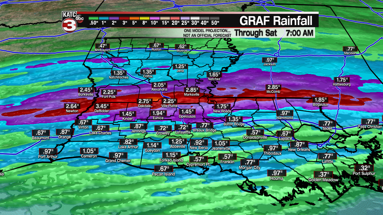
Most of Acadiana however, should see rain totals generally near and inch or less.
Shower activity should taper later Friday night as the front stalls near the Louisiana Coast likely leaving our area with a mostly cloudy weekend as the front makes a move back to the north by Saturday night.
It should be cooler Saturday with highs closer to the lower 60s but milder again Sunday with readings getting back to the 70s.
Rain chances this weekend, while not likely, cannot be ruled out and should stay near the 20% range.
Rain chances look to ramp back up Monday ahead of our next front.
More up and down weather and temperatures are expected for much of next week with more daytime highs reaching the 60s and 70s in the 10 Day Forecast while night-time lows in the 30s are not present...could the dead of our winter be over?
The answer might just be "yes", with no arctic outbreaks reaching the Gulf coast for the next 2 weeks or more (getting us into the first week of February) according to our long range models.
------------------------------------------------------------
Stay in touch with us anytime, anywhere.
To reach the newsroom or report a typo/correction, click HERE.
Sign up for newsletters emailed to your inbox. Select from these options: Breaking News, Evening News Headlines, Latest COVID-19 Headlines, Morning News Headlines, Special Offers
