


Absolutely gorgeous weather out there today with plenty of sunshine and seasonable temperatures in place.
With southerly winds in place and clouds building in late tonight, temperatures will not be nearly as cold as the past couple of mornings.
We will briefly get into the mid-upper 40s tonight (around 9pm midnight), but temperatures will actually rise into the lower 50s by daybreak on Thursday.
Expect mostly cloudy skies and mild conditions out there on your Thursday as temperatures push the lower 70s.
Breezy southerly winds will be at around 15-20 mph throughout the day with gusts at times exceeding 30 mph.

Few spotty showers will be possible by the afternoon, but scattered rain chances will be increasing going into Thursday night/early Friday morning ahead a cold front.

We are mainly going to be dealing with light to moderate shower activity with this front.
No severe weather nor heavy rainfall is expected.
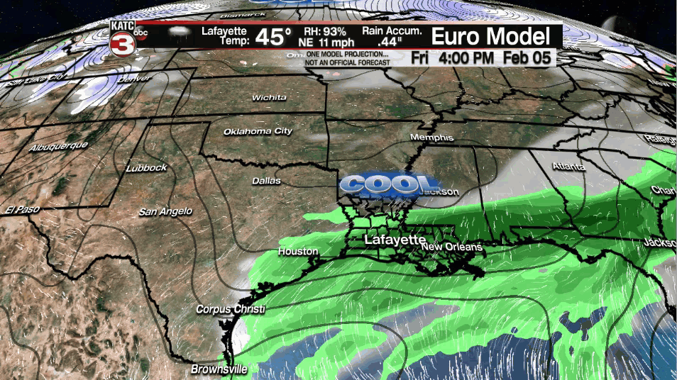
A few spotty showers/light sprinkles will be possible throughout the day on Friday as well, especially along the coastal parishes.
Regardless, clouds will look to linger around, but it will be much cooler as temperatures only hover in the upper 40s to lower 50s.
Upcoming weekend looks workable as temperatures zone in to near normal values for this time of year.
Up and down weather will ensue for next week as milder conditions will be around for the start as temperatures climb into the lower 70s, but trending to colder weather for the latter half of the week.
We may also be looking at more of an unsettled pattern with scattered rain chances remaining in the forecast through mid-late week.
Models still diverge and have not been overly consistent when it comes to a concrete solution for late next week's forecast.
Thus, we will continue to watch the trends in the days ahead...
Here are some climate notes today from Rob when it comes to cold and winter weather in Acadiana:
While the 10 day forecasts by both the GFS & Euro are looking more "interesting" (I won't post their forecasts here because it's 10 days away), just a reminder that the biggest snow and the coldest temperatures ever recorded in the area have occurred in different years during the period of Feb 13-15...
The record snowfall of 14" in Lafayette and 24" in Rayne (22" in Lake Charles pictured here) was record on Feb 14/15, 1895 while the coldest temperatures recorded in Lafayette occurred on Feb 13, 1899 with a low of 6° & high of only 17°!
These records appear safe but we might just see one more chance of winter in about 10 days...will await further model guidance consistency before talking any kind of scenarios.
