


A few isolated showers and storms will be possible this evening as some energy tries to work in from the north.
Mostly quiet conditions after midnight with temperatures falling into the middle 70s.
It'll be a mostly sunny, but muggy start to our Sunday.
Temperatures will climb into the lower 90s by the afternoon under partly cloudy skies.
Some scattered storms will develop through the course of the afternoon and evening with the heating of the day.

Rain chances will sit in the 40% range.
The pattern will stay rather routine through the better part of the upcoming work week.
Temperatures will continue to top out in the lower 90s with the chance to see some cooling showers just about each and every afternoon.
Rain chances will bounce around from ~40-50%.
Be sure to check out my tropical discussion below.
Have a great rest of the weekend!
In the tropics:
The Caribbean really has taken its toll on Fred as it is now just a remnant low.
It continues to battle westerly wind shear due to an upper-level trough in the eastern Gulf.
That will continue to plague the system in the short-term, but that trough will weaken and move northward over the next ~24 hours.
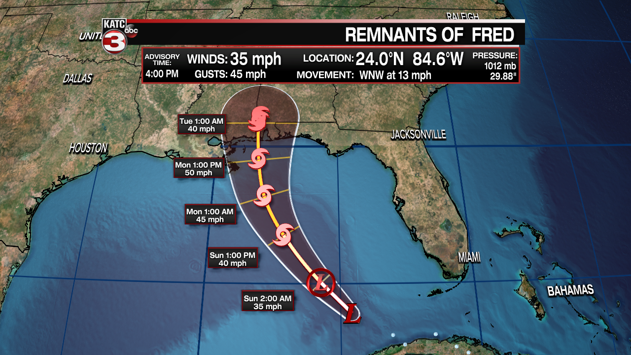
As a result, we are expecting Fred to regain tropical storm status on its approach to the northern Gulf coast.
Landfall is expected to be sometime late Monday into Tuesday near the Alabama/Florida coastlines.
Exact landfall spot is still somewhat up in the air at this point, but impacts will remain well east of Acadiana.
Tropical storm Grace formed in the Atlantic Saturday morning.
It is currently sporting 40 mph winds and is moving at a very fast pace of 26mph to the west.
The big factor initially is going to be its forward speed and land interaction with the Caribbean islands which may take a toll on the system... similar situation as Fred.

It will continue to be steered westward over the next several days through the Caribbean and eventually eastern Gulf of Mexico thanks to the Bermuda High.

Where it will end up thereafter is still a big question mark as forecast confidence begins to decline (talking 5+ days out).
All we can really do at this point is keep an eye on it and track the model trends in the days ahead.
Certainly nothing to get all work up about right now since it is so early in the forecasting process.
Continue to stay with the katc storm team for the very latest.
