


Mostly sunny and hot weather will continue for Acadiana this weekend, but a cool front will bring much more pleasant conditions to the area next week, while the upper support for the front should turn a potential hurricane, perhaps a major one, toward Florida.
In the near term, the ridge of high pressure in the upper atmosphere will continue to support mostly sunny and hot conditions Saturday and Sunday with highs reaching the mid-90s accompanied by heat indices in the lower 100s.

Rain chances will be near 5% Saturday but should improve to 20% Sunday afternoon ahead of our cool front that arrives early Monday.
While Acadiana may see temperatures reaching the lower 90s Monday, cooler conditions and lower humidity should arrive by Monday night setting up some stellar weather for the area for the rest of the week.

Sunny skies, breezy north winds and daily highs closer to the mid-80s are expected next week while nighttime/morning lows dip into the refreshing upper 50s to lower 60s.
Mostly sunny conditions should persist into the following weekend although temperatures may begin to warm back up...we may not be done with the 90s after this weekend/Monday.
See the KATC 10 Day Forecast for the latest.
Meanwhile, the tropics have become hyperactive with no less than 5 systems being tracked Friday afternoon.

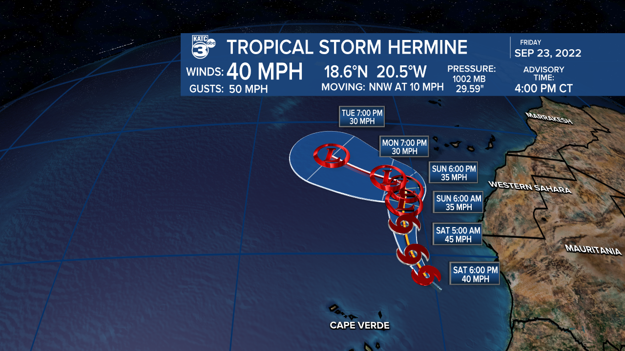
The news of the day is that tropical depressions 9 and 10 formed today, with TD10 upgraded to Tropical Storm Hermine (the 8th tropical storm of the season) by the Coast of Africa.
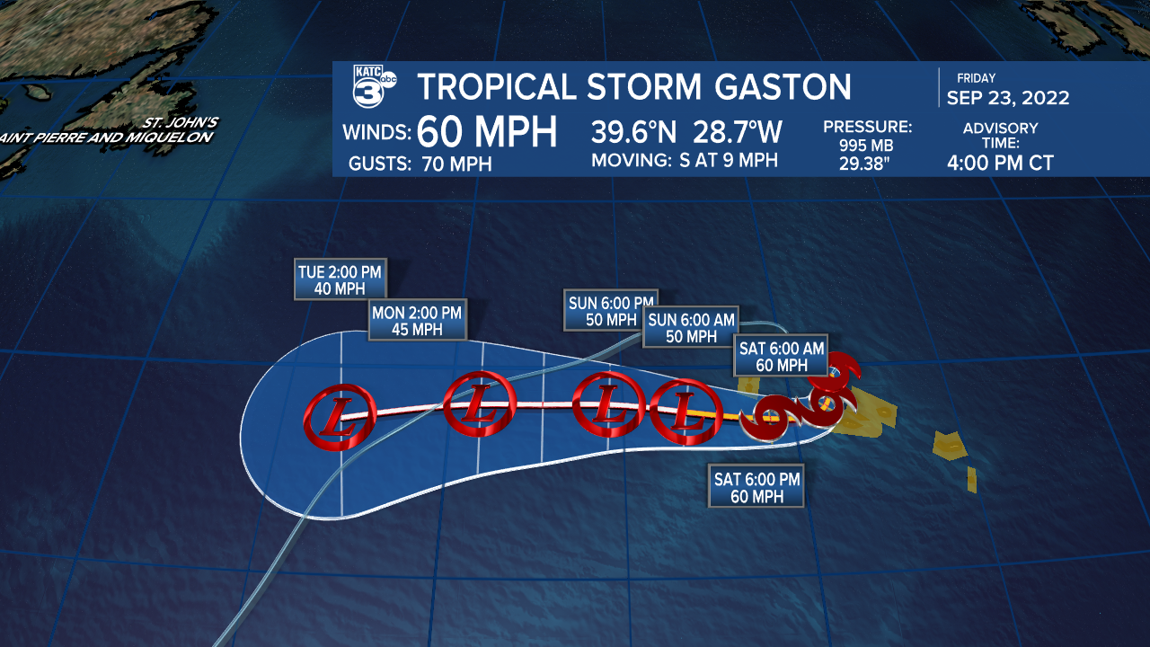
Meanwhile Tropical Storm Gaston continues to meander in the North Atlantic impacting the Azores.
Major Hurricane Fiona with 125 mph winds Friday afternoon is expected to impact the Canadian Atlantic tonight into Saturday with powerful hurricane winds, storm surge and heavy rains...Fiona looks to be one of the most impactful storms in this area in more than a generation.

Farther south, Tropical Depression 9 is expected to become Tropical Storm Ian tonight or Saturday with the system likely to intensify quickly as it traverses the Caribbean and heads toward the Southeastern Gulf of Mexico.

Wind shear over the depression should decrease by Saturday while the storm system will begin to traverse extremely warm Caribbean waters that contain 80° temperatures down to 500 feet.
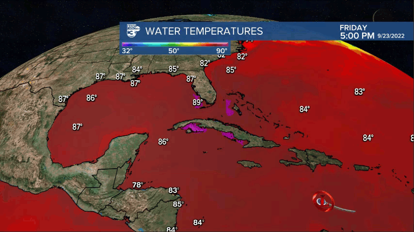
In addition, TD9 will also be moving into a lower shear environment that cold allow for one or more rapid intensification cycles leading to possibly an intense hurricane.
This system is expected to be influenced by the same upper trough bringing Acadiana pleasant weather next week and should steer the system through Western Cuba Monday and impact the Keys and the Southern and Central Florida Peninsula Tuesday into Wednesday.

Currently the National Hurricane Center is forecasting TD9 to be a major storm at landfall (with 115 mph winds) across the Southwest Coast of Florida, but the system could be stronger for landfall in Florida and possibly Cuba.
A Hurricane Watch was posted for the Cayman Islands Monday afternoon while a Tropical Storm Watch was issued for Jamaica.
Stay with KATC Weather App and social media for the latest updates on this system.
------------------------------------------------------------
Stay in touch with us anytime, anywhere.
To reach the newsroom or report a typo/correction, click HERE.
Sign up for newsletters emailed to your inbox. Select from these options: Breaking News, Evening News Headlines, Latest COVID-19 Headlines, Morning News Headlines, Special Offers
