


Acadiana can expect one more hot and relatively dry day Wednesday before higher rain chances return to the area by Thursday afternoon.
Highs Wednesday will likely top out in the mid-90s `thanks to a mostly westerly wind with rain chances limited to the 5-15% range for the area.
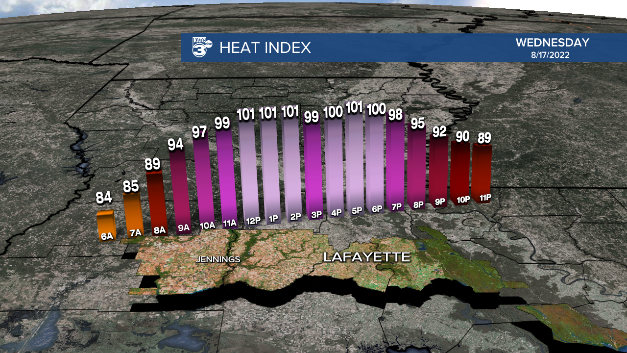
Heat indices will again top out in the 100-105° range Wednesday.
By Thursday, Acadiana will become under the influence of a weak upper level and surface trough providing ample atmospheric destabilization that will lead to much higher rain chances into Friday and perhaps Saturday.

Soaking storms producing a couple of inches of rain will be possible during the Thursday through Saturday time-frame, with the longer range outlook into next week continuing to offer above normal rain chances.
Rain totals in the next week to 10 days should be in the 1-3" range for most of Acadiana with isolated spots possibly receiving nearly double that amount, while the most widespread soaking looks to be closer to the northern part of the state into Arkansas.

And with plenty of rain in the region later this week, our daytime highs will be curbed closer to the 80s.
See the KATC 10 Day Forecast for the latest.
The long range outlooks in the 8-14 day period and 3-4 week period per the Climate Prediction Center look to keep Acadiana and a good part of the Gulf Coast wetter than normal into mid-September...with some tropical activity more than likely baked into the outlooks, especially into September.


Meanwhile, in the tropics, while there are currently several tropical waves in the Atlantic Basin, it's a disturbance moving through Nicaragua and Honduras that may have some potential for development Friday into the early part of the weekend.
This disturbance is expected to emerge in the Bay of Campeche Friday as a weak area of low pressure.

While the risk of development remains low, at 20% as of Tuesday afternoon, another rain-maker is shaping up for Northern Mexico and South Texas, including the Lower Rio Grand Valley this weekend.
This system should pose no direct threats to Louisiana.

It should be noted, the 10 day model forecasts are looking a little busier regarding the tropics with Euro and GFS indicating potential systems emerging in the mid-tropical Atlantic, near the African Coast, and tropical moisture gathering near the Gulf of Mexico.

While confidence in forecasts beyond 7 days is usually quite low, when both models show similar features, and it's be getting to "that time of year", it's worth noting.
------------------------------------------------------
Stay in touch with us anytime, anywhere.
To reach the newsroom or report a typo/correction, click HERE.
Sign up for newsletters emailed to your inbox. Select from these options: Breaking News, Evening News Headlines, Latest COVID-19 Headlines, Morning News Headlines, Special Offers
