


Acadiana's weather pattern will go from spring warmth to summer heat over the next 10 days, with our next best chance of storms arriving Thursday night into early Friday.
In the near term, expect little change to our weather pattern into Wednesday with morning clouds yielding to plenty of afternoon sun as temperatures push for the upper 80s.
The pattern will remain similar into Thursday with the possibility of some more cloud cover at times...temperatures will still reach the mid-upper 80s.

Our next weather-maker primarily in the form of an upper level disturbance and weak surface trough, will be producing the threat of severe weather across West Texas in Oklahoma Wednesday.

The severe weather threat will then advance eastward toward Northeast Texas, Northern Louisiana into Arkansas Thursday.

There looks to be significant (level 3 out of 5) or enhanced threat of severe storms to Acadiana's north Thursday, but by Thursday night into Friday morning some strong storms look to work their way into Acadiana.
The severe weather threat locally for Acadiana looks to be in a marginal risk (level 1 out of 5) to a slight risk (level 2 out of 5) for storms that could be capable of producing damaging winds and hail.
The highest threat areas in Acadiana look to be from western to northern portions of the area, but by the time the storms will be moving through locally the activity could be more scattered rather than widespread in nature.
Rain chances though should increase to 70-80% late Thursday night with activity most likely near/after midnight and ending (hopefully) by midday Friday.
It should quiet down and get hotter into the weekend with only a slight chance (20%) of an isolated storm Saturday while rain chances drop to near zero Sunday.
Daytime highs will begin to climb toward the lower 90s this weekend into early next week.
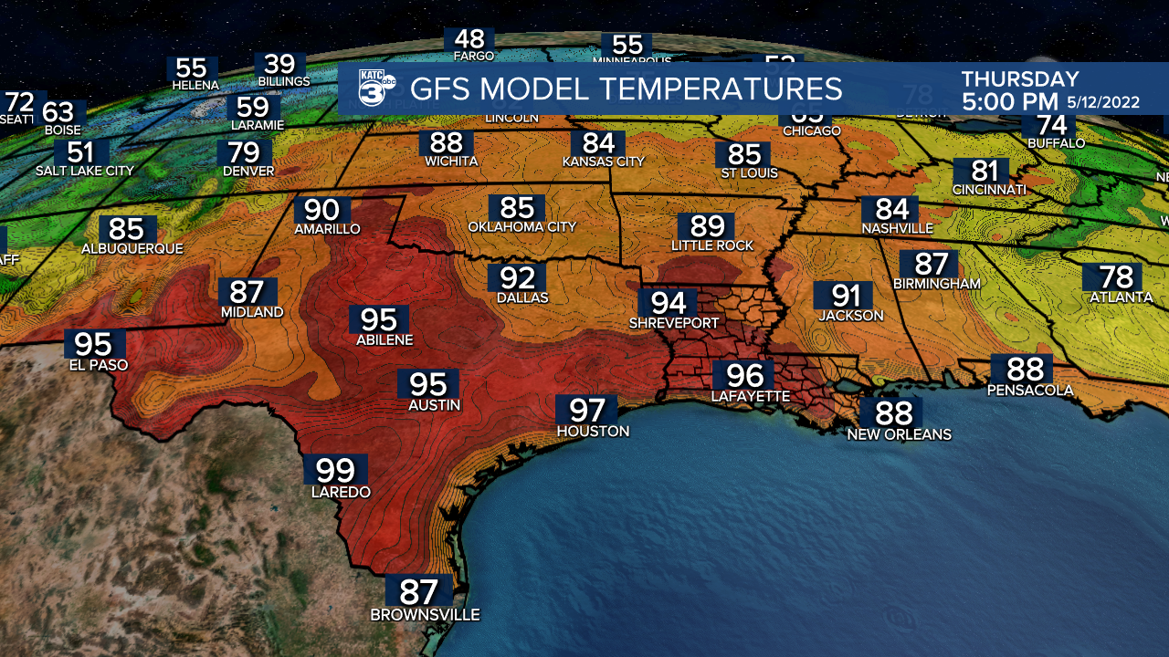
And Tuesday's models (both the GFS and Euro) are showing the possibility of a bit of a heat wave developing mid-late next week as an upper ridge of high pressure builds over the region and surface winds could turn to the north.
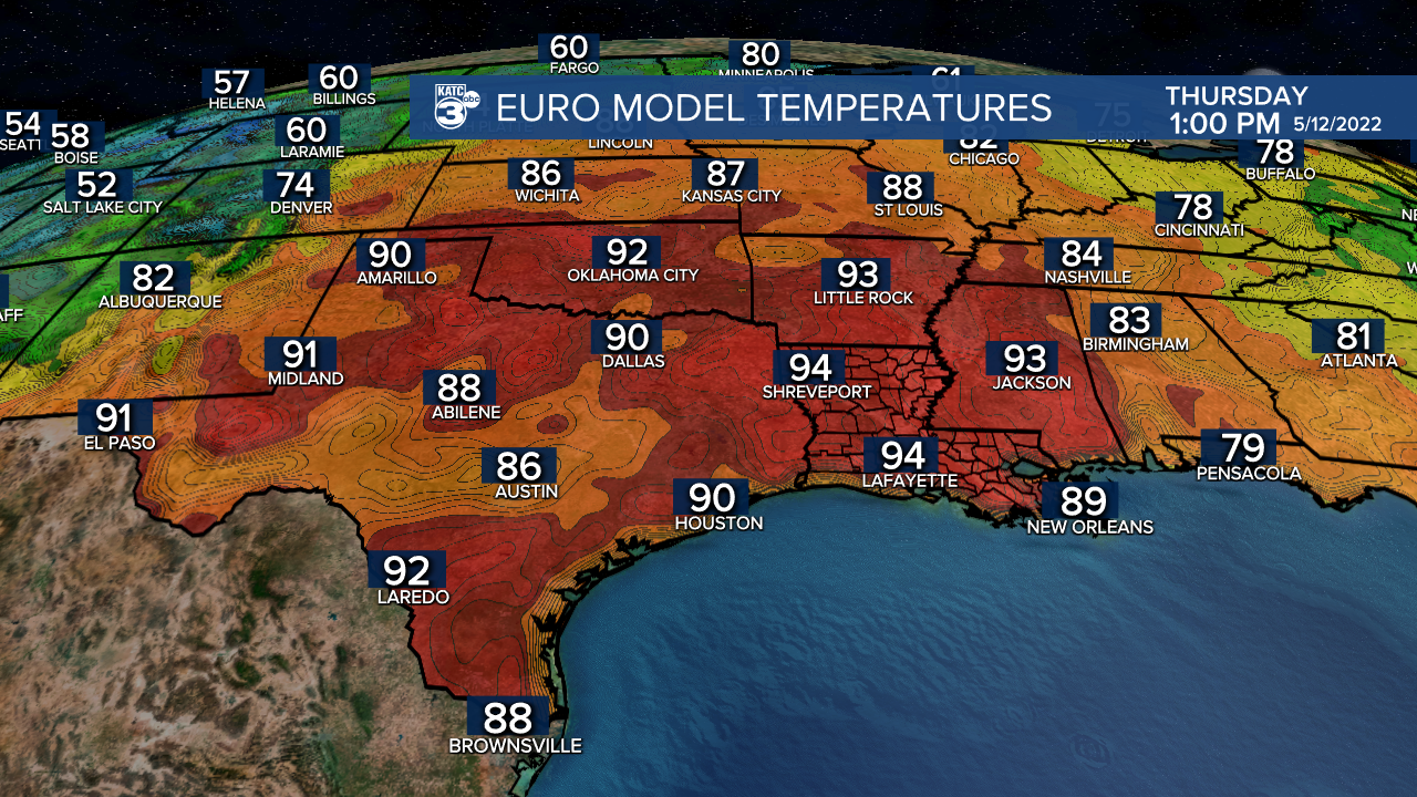
If this indeed verifies, Acadiana could see highs pushing the mid-90s Wednesday through Friday of next week...and if that is the case, we could threaten some record high temperatures!
See the KATC 10 Day Forecast for the latest.
Tropical Notes:
Recently two trends have been noted globally that could impact the upcoming Atlantic hurricanes season that begins in less than a month.
Per Colorado State's expert hurricane forecaster Dr. Phillip Klotzbach, a strong La Niña (strongest on record for April) looks to be developing in the Eastern Tropical Atlantic, if this feature persists, there could be further enhancement of the amount and intensity of storms in the Atlantic Basin.

La Niña which exhibits much cooler than normal sea surface temperatures in the equatorial Eastern Pacific, generally allows for light upper winds and low shear over portions of the Atlantic which usually translates to busier (or much busier) than normal seasons.
In addition, the Tropical Atlantic sea surface temperatures have also become anomalously warm in the Eastern Tropical Atlantic due to lighter than normal easterly trade winds.
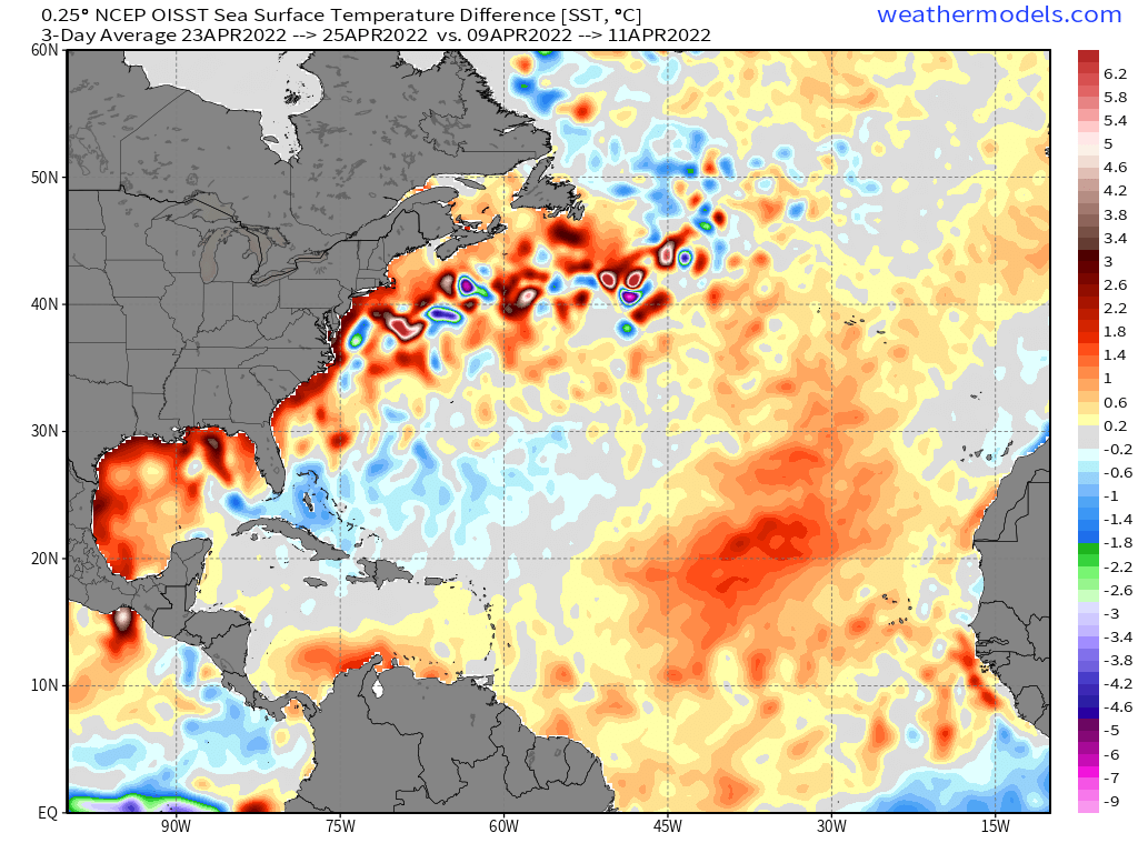
If these two features continue, the number of storms, hurricanes and major hurricanes could increase from the forecasts made just a month ago...not want you want to hear this time of year.
Currently, Dr. Klotzbach is forecasting 19 storms 9 hurricanes and 4 majors in the entire Atlantic Basin (normal is near 14, 7 and 3 respectively)...numbers that may increase in his forecast update that will arrive June 2.
Of course a lot of storms in the Atlantic Basin does not necessarily mean "hits" for Louisiana, but the higher the forecast numbers, the higher the statistical risk will be.
The active 2020 and 2021 Atlantic hurricane seasons could be replicated again his year.
------------------------------------------------------------
Stay in touch with us anytime, anywhere.
To reach the newsroom or report a typo/correction, click HERE.
Sign up for newsletters emailed to your inbox. Select from these options: Breaking News, Evening News Headlines, Latest COVID-19 Headlines, Morning News Headlines, Special Offers
