


The colder air has arrived to Acadiana and it is here to stay... for a while.
Temperatures have remained in the 30s today as wind chills sat in the upper 20s to lower 30s under plenty of cloud cover.
A cold night is ahead as temperatures will be in the lower to mid-30s
We may see a few patchy, light sprinkles out there on Saturday morning, but otherwise, expect plenty of cloud cover once again.

It will be another very cold day on Saturday as temperatures struggle to reach the lower 40s.
A weak, upper-level impulse will approach the region late Saturday into Sunday.
That may help to generate some precipitation chances..
We would mainly be looking at a light cold rain situation for this time period, but some sleet pellets may try and work in, especially for our northern parishes and the closer you get to CenLA.
We are not expecting ice accumulations for anything that falls on Sunday at this time as well.
We will monitor trends over the next 24 hours.
Temperatures will hold steady on Sunday in the 30s/40s.
A more impressive upper-level feature, which will induce surface low pressure in the Gulf, will begin to approach from the west on Monday.
This impending storm system is the one that will give us the best chance to see winter precipitation with colder air already in place.

Atmospheric profiles continue to show Freezing Rain/Sleet as being the dominate precipitation type on Monday.
This will set-up for some icy, slick conditions late Monday going into Tuesday.

In fact, both the GFS and Euro are suggesting that we could see ice accumulations around .25"-.50+".
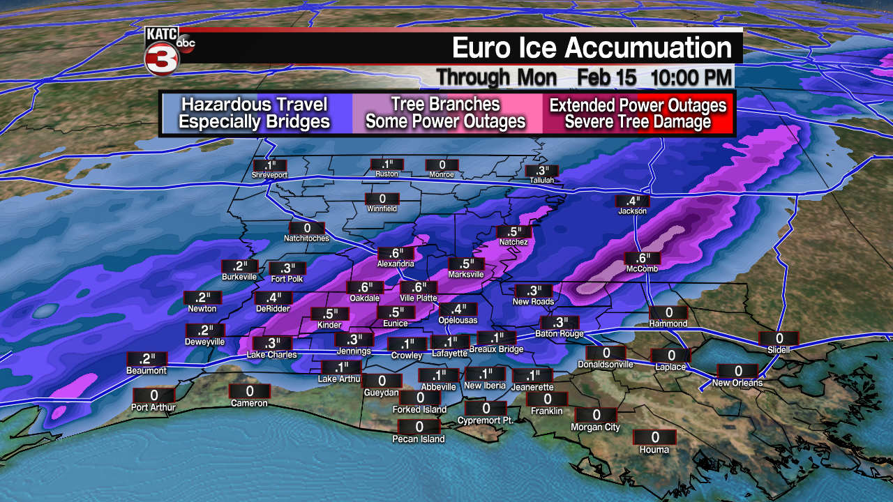
Important to keep in mind that any ice accumulating to more than .25" could lead to some downed tree limbs and perhaps isolated power outages.
This is something that we will have to watch very closely in the days ahead to see how the numbers evolve.
Regardless, driving conditions are likely going to become quite treacherous late Monday into Tuesday, so keep that in mind if you have travel plans.
Make sure to heed the warnings from local law enforcement officials and check travel conditions before you head out.

Also, a reminder that bridges and overpasses will ice over *before* the surface roadways.
Record setting cold is still forecasted for Tuesday morning (Mardi Gras) with temperatures expected to be in the teens to lower 20s.
*The record is 22° set way back in 1895...Euro forecast: 21° & GFS: 10°!
Wind chills will likely be in the single digits..
Temperatures will struggle to get above freezing on Tuesday afternoon.
Driving conditions may stay dicey through Wednesday morning but it depends how warm we can get on Tuesday AND just how much ice accumulates.
Moving down the road... yet another system will approach the area late Wednesday into Thursday leading to precipitation chances.
As of now, it appears we will only be dealing with a cold rain event for this system, but something we will continue to keep an eye on.
We then may have another shot at a hard freeze for the end of next week before finally seeing a gradual warming trend into the following weekend.
Make sure to check KATC'S 10-day forecast as well!
Of course, make sure those exposed pipes are wrapped and ready to go.
Stay warm and bundle up out there!
