


The risk of showers and thunderstorms will begin to ease across Acadiana for the rest of the week, but there will still be a chance of scattered activity during the afternoon/early evening hours.
A weak surface low pressure and frontal trough has settled across Acadiana and Southern Louisiana.
This system was responsible for producing several inches of rain across Acadiana since Monday.

Some spots approached 5" or more from Lafayette in Acadia Parish, but the news is a little better for our soggy situation.

The weak surface low is expected to advance northeastward into Wednesday leaving plenty of clouds on it's backside, but perhaps a more stable atmosphere which should limit our rain chances to the afternoon hours (near 40%).

As a result temperatures will approach 90° Tuesday with heat indices pushing past 100°...especially when a few expected intervals of sun are mixed in.
Thursday should bring more of the same, still with a better than normal rain chances near 50%, but still an improvement over the last couple of days.
High pressure will try to bank in from the Gulf of Mexico as we finish out the week and head into the weekend which should help reduce the overall risk of afternoon showers and storms closer to 20-30%...so we wont be completely dry, but there should be a lot less activity on the radar.

Daytime highs will begin to climb well into the lower 90s which will finally make it feel more like summer!
The pattern next week maintains typical summer conditions with hot and humid weather accompanied by a few scattered afternoon storms.
See the KATC 10 Day Forecast for the latest.
In climate news, Lafayette is sitting just 5" short of what we normally expect in an entire year!
After a dry start to the year it turned toward wetter than normal conditions April, followed by May, the second wettest on record.
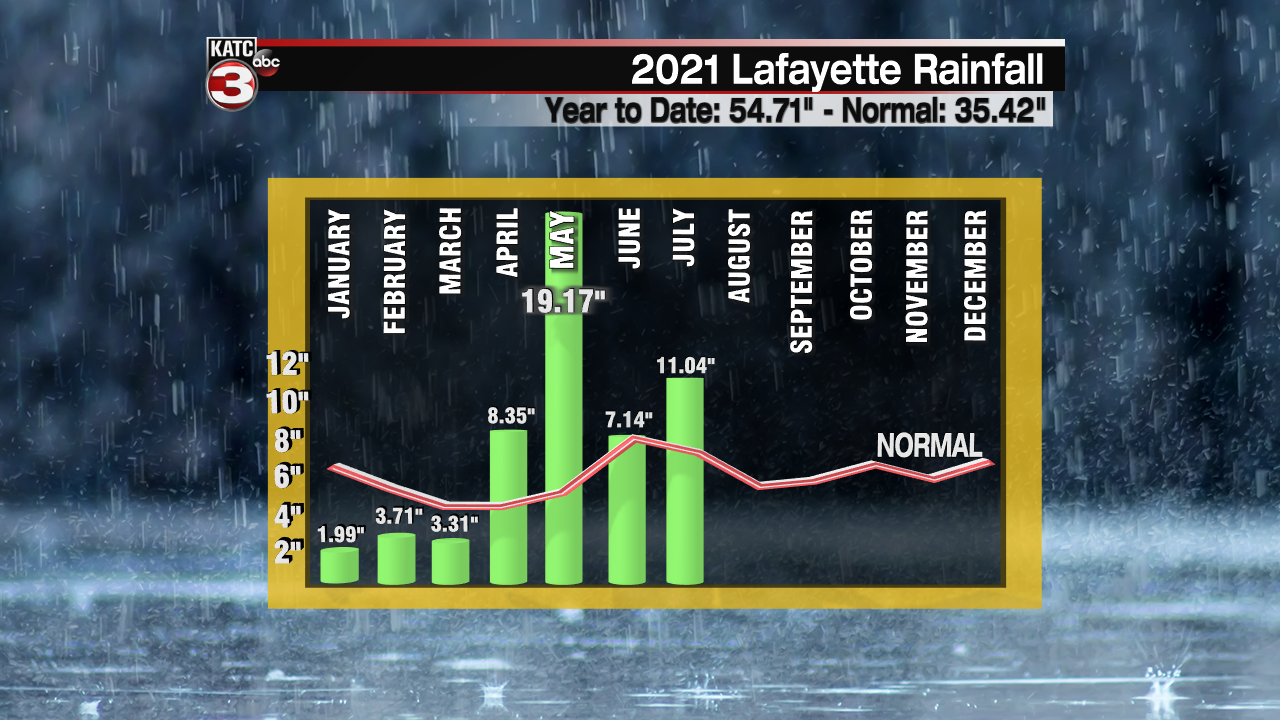
In June it rained 21 out of 30 days even though our totals were near normal.
We haven't looked back since with the exception of one day at the airport, rain has been registered every day this month!
And there are plenty of other spots in Acadiana and Southern Louisiana that have been much wetter than Lafayette!
What's causing this you may ask? Well part of it is variability and a persistent funky pattern, but the other part can be attributed to a warmer Gulf of Mexico as compared with the 20th century average, that heats our atmosphere which then holds more moisture.
Add a slower, wavier jet stream thanks to a warmer worldwide climate, and it is indeed the recipe for more persistent wet Gulf Coast patterns, and in turn, more extremes...and perhaps a glimpse of our years and summers ahead.
Now mind you, one would think our temperatures should be below normal with this wet pattern and you'd be partially right for daytime highs...but it's the sneaky elevated night-time lows that continue to run above normal in recent years that's keeping our averages at or above normal...which is the back signal/connection coming from the Gulf.
-----------------------------------------------------------
Stay in touch with us anytime, anywhere.
To reach the newsroom or report a typo/correction, click HERE.
Sign up for newsletters emailed to your inbox. Select from these options: Breaking News, Evening News Headlines, Latest COVID-19 Headlines, Morning News Headlines, Special Offers
