


It will be a breezy and milder weekend for Acadiana ahead of our next weather-maker that promises to bring widespread rain and some storms to the area Sunday.
In the near term, a gradual increase in clouds from the southwest accompanied by east to southeast winds will allow temperatures to hold in the 40s overnight through daybreak Saturday.

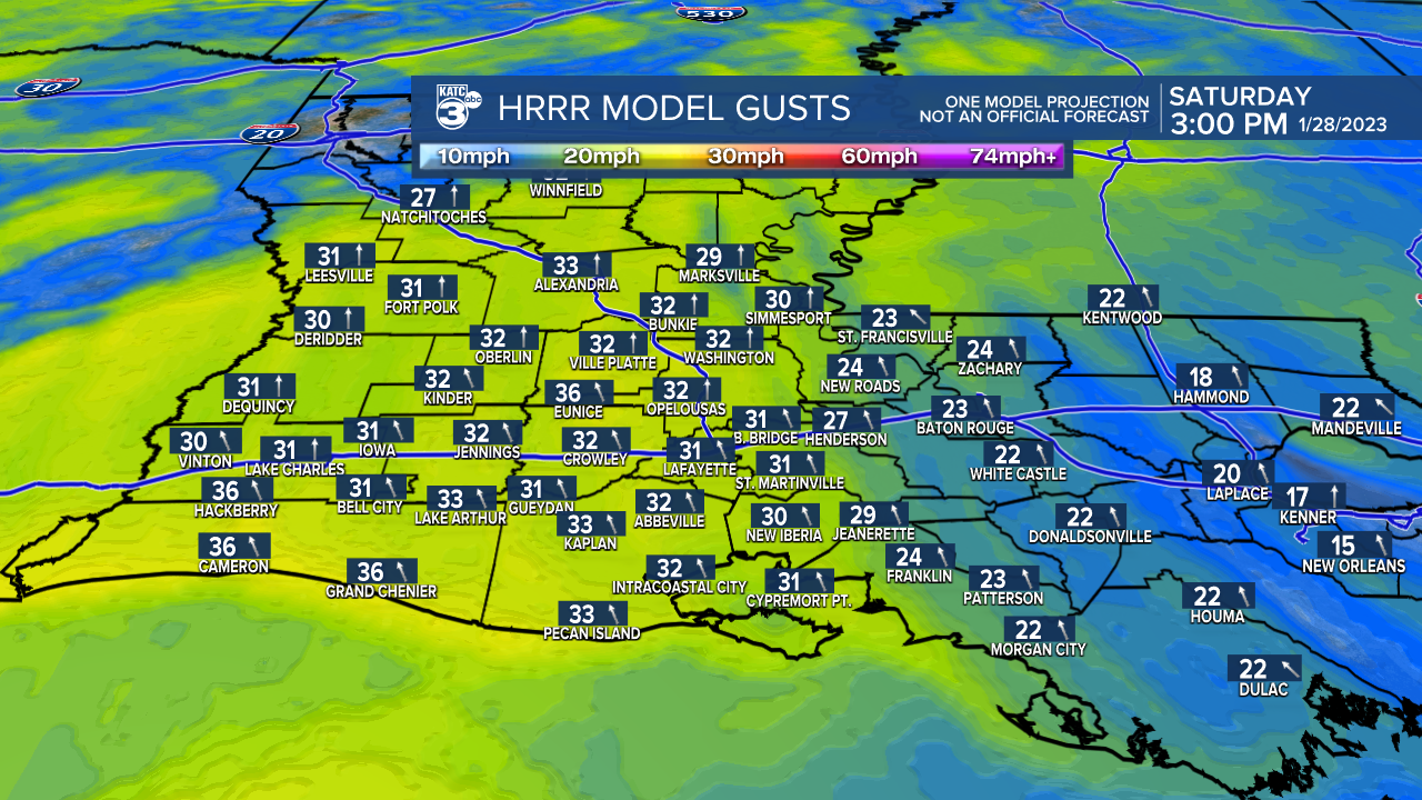
Saturday will be a mostly cloudy, breezy and milder day with highs reaching into the lower 70s when a few intervals of sun will be possible into the afternoon.
Wind will increase Saturday from the south to southeast near 15-25 mph with some gusts pushing the 30-35 mph range, especially during the afternoon.
Clouds will thicken as temperatures hold in the much milder 60s Saturday night with patchy rain shower activity likely developing after midnight.
Rain chances will go from near 60-70% late Saturday night to near 100% Sunday...a 100% doesn't necessarily mean it will rain all day, or that the rain will be heavy, but in this case, it probably will apply on both accounts.

The Weather Prediction Center (WPC) has all of Acadiana hatched in for a slight risk of excessive rainfall Sunday, and the WPC is also forecast 2-3" up to 4" in spots for our area.

Computer model guidance is similar in their forecasts with a lot of variability possible...so bottom line, expect 1-3" most areas of Acadiana Sunday, but do not be surprised if we have a couple of isolated hots spots where up to 4-6" might be possible.

It should be noted, the last three weather systems that impacted Acadiana form the Pacific Ocean have brought more rain than was forecast by models and humans alike...Sunday's system could have similar characteristics.
Some localized street flooding therefore, may be possible as the day wears on Sunday.
In addition to the threat of locally heavy rainfall, the Storm Prediction Center has Acadiana hatched in for a low end, "marginal risk" of a few isolated severe storms.

The main severe weather threat would be for some storms that could contain small hail, damaging winds and perhaps a very low-end threat of an isolated tornado.
Bottom line: stay weather aware into Sunday.
Thereafter, the pattern looks unsettled with some rain chances likely toward the middle part of next week.
A stronger front should arrive Thursday bringing back some chilly winter temperatures to the region into the following weekend.
See the KATC 10 Day Forecast for the latest.
------------------------------------------------------------
Stay in touch with us anytime, anywhere.
To reach the newsroom or report a typo/correction, click HERE.
Sign up for newsletters emailed to your inbox. Select from these options: Breaking News, Evening News Headlines, Latest COVID-19 Headlines, Morning News Headlines, Special Offers
