


Acadiana will stay in active pattern for showers and thunderstorms overnight into Tuesday as a weak frontal trough adds instability and will be the focusing mechanism providing atmospheric lift.
Latest models indicate that Acadiana will see an 80% chance of storms into Monday evening, with some activity possibly tapering for a period overnight before firing back up again toward daybreak.

While widespread severe weather is not expected, some storms will contain gusty winds, perhaps some small hail and will be capable of producing torrential downpours.
The chance of showers and storms Tuesday will be in the 60-70% range, with best times for storminess in the morning and perhaps again in the latter part of the afternoon (per the HRRR Model).
Model guidance suggest that most of us will see 1/2" to 1" of rainfall through Tuesday, but where storms frequent, upwards of 3-5" of rain will be possible resulting in at the very least, some localized street flooding.
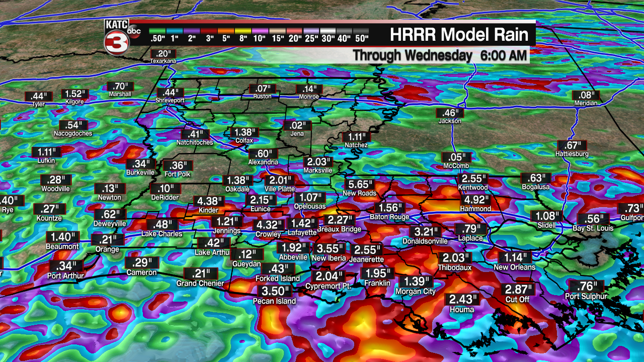
Fortunately our ground has dried more appreciably since our record May rains, so flood watches are not posted for the area at this time.
The aforementioned frontal trough will dissipate across the area into Wednesday, with still the chance of storms (40%), but activity should be more scattered in nature.
A typical June pattern is anticipated for the rest of the week with rain chances in the 30-40% range into the weekend...an upper trough will approach the area this weekend into next week which could enhance the daily chance of showers and storms at that time.
Look for high temperatures closer to the mid-80s Tuesday, and upper 80s to near 90 for the rest of the KATC 10 Day Forecast.
Meanwhile in the tropics, while Tropical Storm Claudette is moving out to sea, a new tropical wave has been identified by the National Hurricane Center (NHC) in the mid-tropical Atlantic.

This wave has a low chance of development over the next few days, but is expected to run into a more hostile environment in the Caribbean.
Thereafter, the GFS model has been picking up on this wave/feature and developing it once to reaches the Northwest Caribbean/Southern Gulf of Mexico in the 8-10 period.
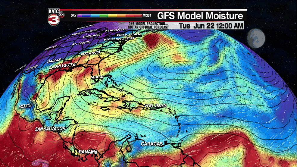
It should be noted that over the last couple of days the GFS has continued to indicate something may be up in the Gulf of Mexico around the 1st of July...but where any potential system goes, is anyone's guess at this time.
The GFS did a respectable job "bird-dogging" the possibility of Tropical Storm Claudette more than 10 days out, so it should be given some weight to its forecasts for now.
------------------------------------------------------------
Stay in touch with us anytime, anywhere.
To reach the newsroom or report a typo/correction, click HERE.
Sign up for newsletters emailed to your inbox. Select from these options: Breaking News, Evening News Headlines, Latest COVID-19 Headlines, Morning News Headlines, Special Offers
