


Despite a tropical disturbance showing more organization in the Gulf of Mexico Friday, the weather pattern will improve for Acadiana as drier, more stable air advances in from the east.

The National Hurricane Center (NHC) upped the odds to 60% of development of a system in the Western Gulf of Mexico as of Friday afternoon, but the system will have a limited chance for that development as the feature should move into the Texas Coast by early Saturday morning.
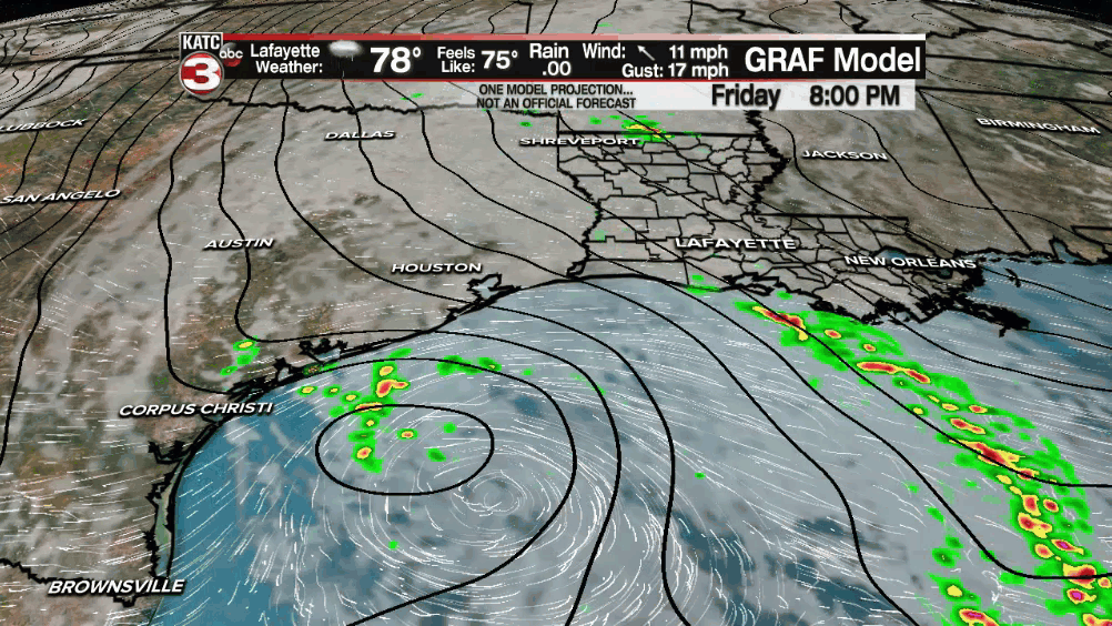
This disturbance could enhance some of the lingering tropical showers across Southwest Louisiana into Southeast Texas through Saturday where a Flash Flood Watch was maintained through Saturday morning.

Elsewhere across Acadiana, the Flood Watch has been dropped.
In addition, with breezy southeasterly winds banking up along the coast, tides will likely run 1-2 feet above normal through Saturday, thus a Coastal Flood Advisory is in effect along the entire Louisiana coastline...tide levels should begin to decrease Sunday.

Inland there will still be a 30-40% chance of a few lingering showers for Acadiana overnight through Saturday morning, but mainly toward Southwest Louisiana.
Temperatures Saturday morning should drop into the upper 60s to near 70°.
After plenty of clouds early Saturday look for intervals of sun to return to the area into the afternoon as temperatures climb back into the mid-80s.
A few brief showers could still pop-up across the area with daytime heating Saturday afternoon, especially with all the standing water on the ground due to the heavy rains this week.

Most of Acadiana received anywhere from 6-12" of rain during the course of the week with some hot spots exceed 15" and approaching 20"

A solid foot of rain or more fell over Lafayette Parish especially across the central and eastern part of the parish.
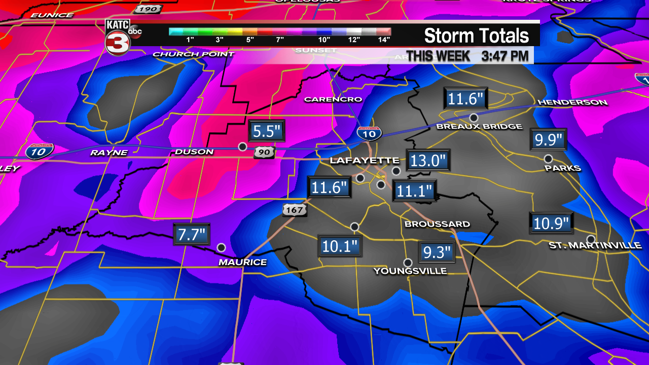
Doppler estimates shown probably are underdone across many areas given some higher rain gauge reports received at KATC.
Moving into Sunday, even drier more stable air will move in, leading to more sunshine and rain chances dipping down to 10% or less along with more comfortable humidity and pleasant overnight temperatures.
Next week will start of dry and pleasant but humidity will gradually be on the increase along with the chance of a few widely scattered showers (near 20% or less) on any given day mid to late next week and into the following weekend.
See the KATC 10 Day Forecast for the latest.
Elsewhere in the tropics, another sub-tropical disturbance may get upgraded by the NHC into this weekend, but that system will not impact the U.S.

The first two names on the Atlantic list this year are Ana and Bill.
------------------------------------------------------------
Stay in touch with us anytime, anywhere.
To reach the newsroom or report a typo/correction, click HERE.
Sign up for newsletters emailed to your inbox. Select from these options: Breaking News, Evening News Headlines, Latest COVID-19 Headlines, Morning News Headlines, Special Offers
