


While the weather will remain mostly sunny this weekend, there will likely be a touch of summer in the air thanks to temperatures nearing 90° and a gradual increase in humidity through Sunday.
Look for clear skies accompanied by seasonable temperatures mostly in the mid-60s for our Saturday morning.

A few patches of ground fog, mainly in the more rural areas will be possible by daybreak.
Expect plenty of sunshine for our Saturday with highs in the upper 80s to 90° in a few spots.

Light and variable winds Saturday should turn southeasterly by day's end marking the gradual commencement of increasing dew points and thereby humidity, working its way into the region.
After a morning start in the mid-upper 60s Sunday look for more sunshine accompanied by high temperatures in the upper 80s to near 90°.
And with slightly higher humidity Sunday, it will definitely feel more summer-like, and that pattern will carry into next week.
A frontal system will approach the region into Monday but will likely stall well to our west.

As a result look for partly cloudy, warm and humid conditions into next week, along with the chance of a few scattered daytime showers.
The weather pattern is beginning to look more interesting on several fronts (pun intended), toward the end of next week and into the following weekend.
It appears the a cool front will be edging closer to our region toward the end of next week, but at the same time there could be some modest tropical development underway in the Gulf of Mexico as tropical moisture builds from the Caribbean per the latest trends in the GFS model.
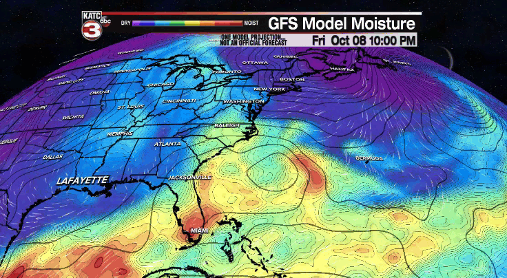
For now, it does appear to be getting cooler for Acadiana by next weekend, but the question thereafter will be whether something gets brewing in the Gulf and if there will be a tropical moisture conduit working toward the region.
For now the 10 Day Forecast is "in" on cooler temperatures in the 7-10 day period, but a "hedge" on any local tropical impacts...no worries locally for now, but something to watch going into next week.
Needless to say, climatologically-speaking we are far from being done with "tropical" season.
Elsewhere in the tropics, a disturbance off of the Carolina coasts became a little more organized Friday and now has a "medium" (40%) chance of "sub-tropical" development over the next few days.

This feature should be a relatively low-impact system but will likely produce breezy conditions, rip tides and provide for some coastal erosion from the Carolinas northward to the Mid-Atlantic states this weekend into early next week.
------------------------------------------------------------
Stay in touch with us anytime, anywhere.
To reach the newsroom or report a typo/correction, click HERE.
Sign up for newsletters emailed to your inbox. Select from these options: Breaking News, Evening News Headlines, Latest COVID-19 Headlines, Morning News Headlines, Special Offers
