


While a good chance of daytime showers and thunderstorms is expected to remain in the forecast for Acadiana into the weekend, it appears that we may get to see a little more sun before the mainly afternoon storms kick in.

A weak upper low and surface trough in the North-Central Gulf of Mexico will continue to slide westward toward Texas this weekend.

While this feature will continue to shuttle tropical moisture into the area, the extra instability associated with it should gradually diminish across our part of the world Friday into the weekend as more storms concentrate offshore.

This means while we still see above normal summer rain chances across the region, the activity may eventually get delayed more into the afternoon hours leaving us with a little more sun and temperatures maxing-out closer to 90° in the days ahead.
Scattered mainly afternoon showers and storms will remain with us into much of next week, with models also hinting at a weak upper trough/frontal system nearing the Gulf Coast State mid-late next week.
This feature may actually lead to more enhanced rain chances again, but we could possibly see drier conditions for the weekend that follows, but for now that is not overtly depicted in the latest KATC 10 Dy Forecast.
Meanwhile the tropics remain relatively quiet with the only remarkable features being a tropical wave emerging off of the African Coast and the disturbance in the Northern Gulf.

While no developments are expected anywhere in the next 5 days, the African Coast wave should reach the Caribbean in about 10 days, and thereafter may have an opportunity to develop about two weeks down the road.
And this program note: with the busiest part of hurricane season fast approaching please join us tonight for "Weathering the Storm", a KATC Hurricane Special airing immediately after our 5pm newscast at 5:30pm!
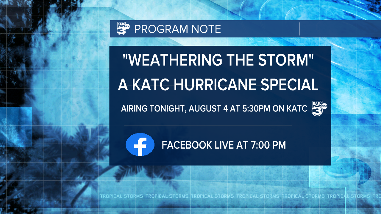
We'll hear from the Director of the National Hurricane Center, Jaime Rhome with the special program featuring the latest tech in tracking and forecasting storms, and addressing some real issues facing our hurricane battered state, including storm PTSD.
Following the program Chief Meteorlogist Rob Perillo will be live on KATC's Facebook and katc.com's web pages at 7:00 pm Thursday to take your questions and address concerns.
Hurricane Seasonal Forecast Update: on Thursday NOAA and Colorado State's Dr Phillip Klotzbach updated their forecasts for the balance of the Atlantic Tropical Season.
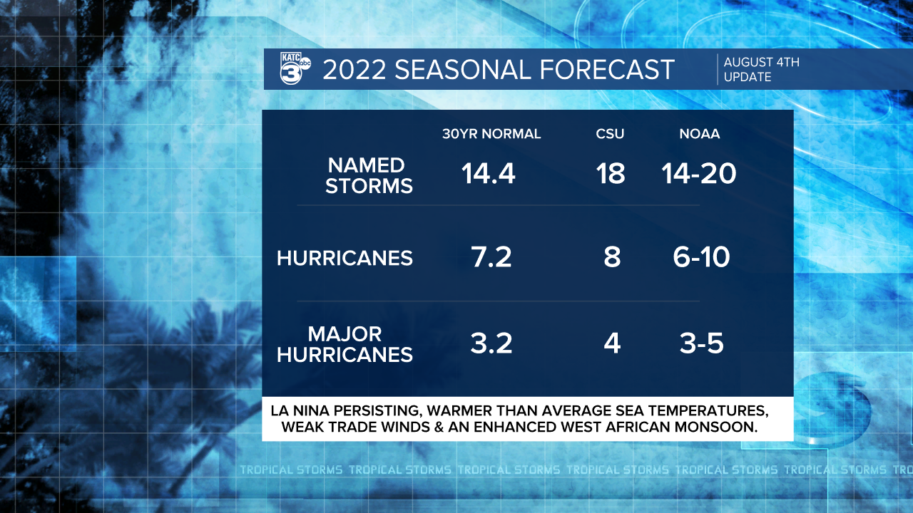
A busier than normal season is expected by both groups but they have nudged down the numbers a storm or two.
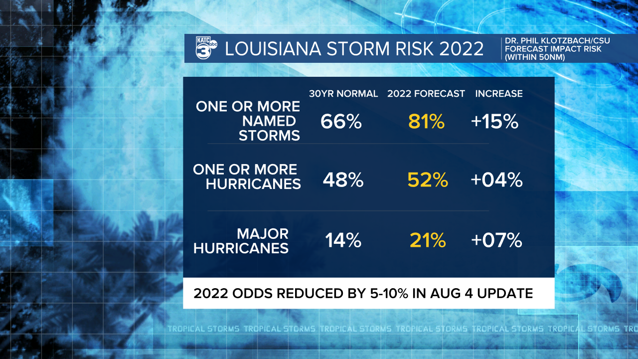
We can't forecast where storms will impact, but it only takes one storm at your location to make it a bad season
------------------------------------------------------------
Stay in touch with us anytime, anywhere.
To reach the newsroom or report a typo/correction, click HERE.
Sign up for newsletters emailed to your inbox. Select from these options: Breaking News, Evening News Headlines, Latest COVID-19 Headlines, Morning News Headlines, Special Offers
