


Acadiana's spring temperatures will continue for the next week, but some spring showers will enter the forecast Wednesday, with prospects of scattered showers and storms increasing this weekend.
In the near term, expect mild temperatures tonight with lows in the mid-upper 60s...normal this time of year should be near 50°.
Some patchy fog is possible toward daybreak, but may not be as widespread as the last two nights/mornings.
Tomorrow will bring the chance of scattered showers and perhaps an isolated thunderstorm, with best rain chances over toward Eastern Louisiana.

Today's HRRR Model is more robust with the scattered activity as compared with the "quieter" and more isolated GRAF Model.

A blend of the two will be best setting rain chances in the 30% range with lower chances west and better chances to the east.
Highs Wednesday should reach the lower 80s once again, more than 10° above normal.
Thursday and Friday will bring little change although the chance of a shower will be closer to 20% or less.
A frontal trough and a series of upper disturbances should bring a better chance of scattered showers and a few thunderstorms this weekend. Rain chances will be closer to 50-50% this weekend, and may go higher for one or both days.

We are not expecting any organized/widespread severe storms at this time.
The spring severe weather season however, will kick off for portions of the climatologically favored areas to our west this week.

Risk levels inch upward Friday...and more outlook areas are likely to come this weekend, and perhaps in our neck of the woods in Louisiana by mid-next week.

Best prospects of severe storms may arrive to Louisiana in about a week...still centered on next Wednesday...of course forecast and outlooks areas and risk levels may change, but this is what we have for today...

And the Storm prediction Center is not outlining any areas beyond Friday yet, as predictability is too low at this time.
Se the KATC 10 Day Forecast for the latest.
Temperature notes and climate of this past winter:
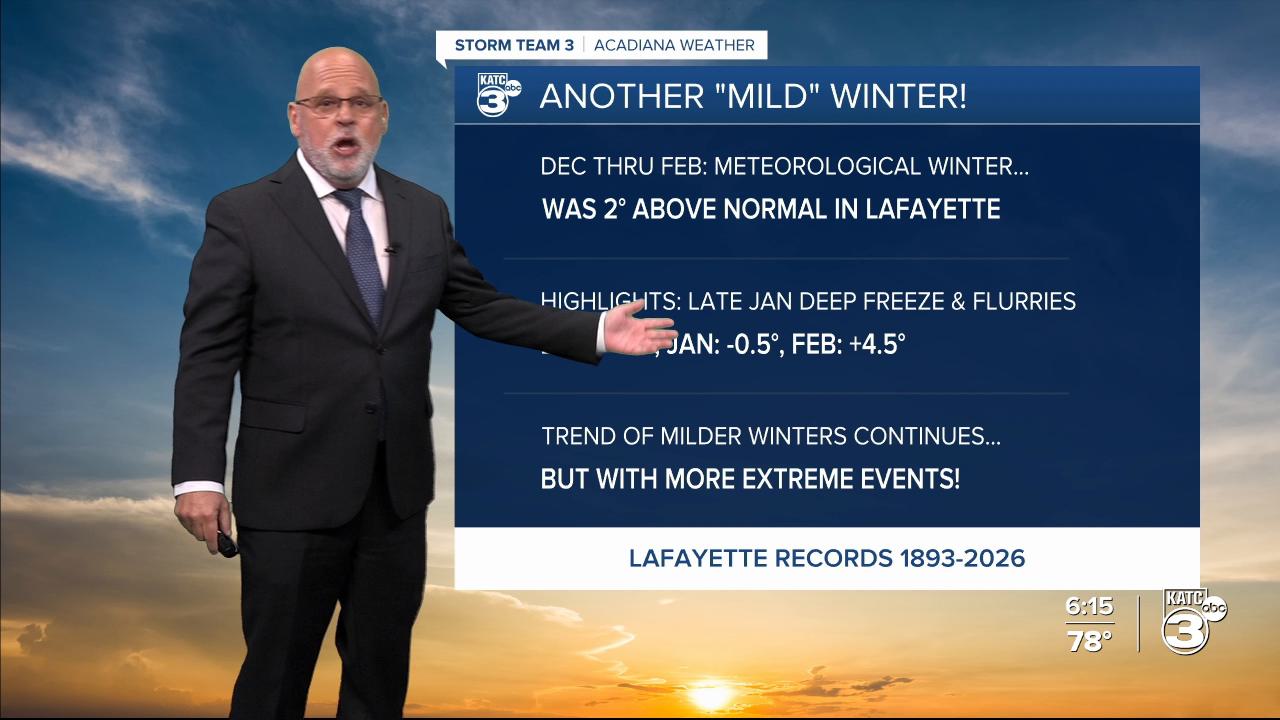
It was no surprise, another milder than normal winter for Acadiana!
Winter temperatures for Lafayette from December 2025 through February 2026 averaged 2° above normal.
December was 1.9° above normal, January was 0.5° below normal, while February came through at a solid 4.5° above normal, and 2° milder than last February.

We were forecasting a milder than normal winter last fall, but everybody will remember the deep freeze and the "near" ice storm locally, followed by flurries in late January, that was accompanied by 3 nights in the lower 20s in Lafayette, and upper teens to the north.
The trend of the last couple of decades continues with overall milder winters in Acadiana, but with more brief extreme cold/winter outbreaks/events sandwiched in...all thanks to a wavier jet stream, due pronounced polar warming that continues to displace chunks of the polar vortex and its brutal cold farther southward.
I would expect much the same in the winters ahead with overall warmer winters accompanied by the occasional extreme event, which ultimately could bring more snow and/or ice events to our area, which normally in the past, have occurred once every 4-5 years...but now, maybe more frequently...so there's that!
