


Web Forecast Layout:
1. Tonight's Severe Weather
- Modes of Severe Weather Risk (Tornado, Hail, Wind, Flood) & current Tornado/Flood Watch areas.
- Storm Timing
2. Tomorrow's Flood Potential
3. 10 Day Forecast
——-
1. Tonight's Severe Weather
Acadiana is hatched into a level (2/5) risk of severe weather through 7 AM Wednesday.

- Modes of Severe Weather Risk (Tornado, Hail, Wind, Flood)


Tornado threat has sneakily increased throughout the day. With a 5% chance of seeing an EF2 within any of the brown area, and within the yellow hatched area can see EF3+ long tracked, more violent tornadoes. Do not ignore the tornado risk while thinking of the flooding.

Hail has already outperformed this forecasted value, and is expected to continue to be a threat, but I think we see this one diminish with time tonight as storms become more linear in nature. I wouldn't expect much, if any, hail after 3 AM.

Wind gusts ahead of the mainline of storms between 10 pm and 2 am are forecasted to reach between 30-40 MPH. Be alert to damaging wind potential as the main line arrives, this will also calm down after the initial storms overnight into later tomorrow morning.
- Storm Timing
This is where the forecast gets dicey and models diverge in thoughts. Severe weather can start as soon as now in Cameron Parish, with strongest storms likely by 10 pm - 12 am, roughly. Give or take a few hours.

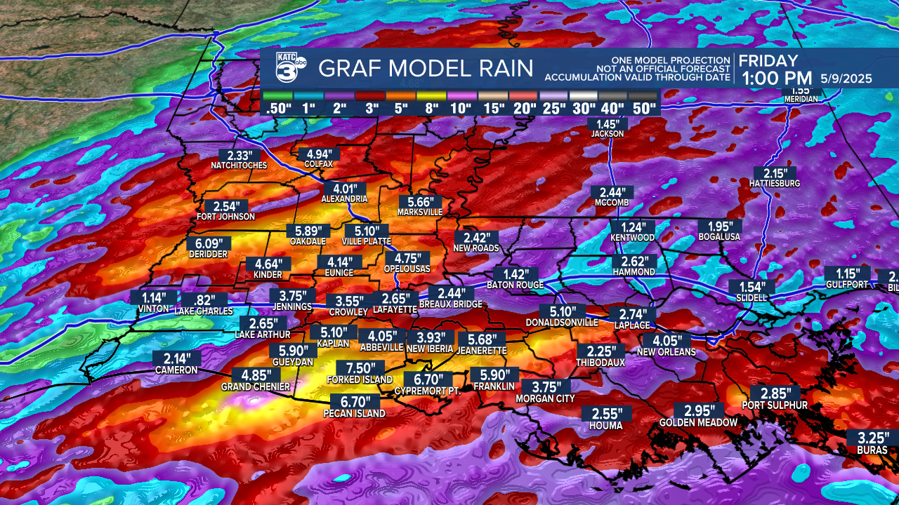
2. Tomorrow's Flood Potential
We have gone back and forth on this entirely. Here are two model depictions. A full discussion can be found here if you want the knitty-gritty on the totals
Bottom line, be prepared for 3-8" locally, with higher pockets of 10-12 hot spots embedded. But, expect to see this likely unfold more in CenLa and in the SW coast of Louisiana, more than previously thought in Lafayette Parish.

PS: IF you use my forecast, graphics, or agree with me strongly enough to reuse my wording, please provide credit. I appreciate the support.
