
1PM update: Michael intensifies with winds up to 155 mph as it officially makes landfall near Mexico Beach, Florida.
This makes Michael the strongest hurricane to ever make landfall along the Florida panhandle.
Michael is expected to cause life-threatening impacts from storm surge near 6-10 feet, strong hurricane force winds and heavy rains for a large portion of the Florida panhandle.

12pm update: The outer eyewall of Michael is beginning to make landfall between Panama City Beach and St. Vincent Island with possible 150 mph winds.

– – – – – – – – – – – – – – – – – – – – – –
It's wild how fast it's moving and that this thing may be a Cat 2 in Georgia tonight. That is not typical. pic.twitter.com/iVZ5ZUFNhh
— Daniel Phillips (@DanielKATC) October 10, 2018

Hurricane Michael, now a category 4 storm, continues to show signs of strengthening and may be a border line category 5 at time of landfall. Moving quickly Michael should be pushing onshore Wednesday afternoon and into Georgia by early Thursday morning, which will limit some of the flooding caused by rain. This of course is only a little good news in a storm that otherwise will be a full on natural disaster.
The track of the storm has not shifted much, if at all over the last day or two, and it appears on satellite that Michael is starting its turn to the east. Landfall is still expected to be just after lunch on Wednesday, but the early winds and rain have already been moving onshore. Conditions will rapidly deteriorate through the day along the Florida Panhandle.
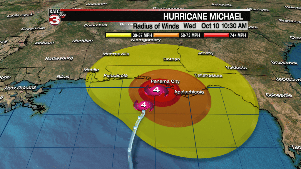
The strongest winds will remain close to the center with hurricane force winds spreading out in a 45 mile an hour radius, tropical storm forced winds will spread out 185 miles from the center of the storm. This means the strongest winds will stretch from roughly the 30A region through Panama City to about Port St. Joe on the eastern side.
These winds produce widespread damage and since the storm is moving so quickly hurricane forced winds will be felt all the way up in central Georgia as it barrels forward. These winds are obviously strong enough to cause significant damage to roofs, knock down trees and power lines, as well as hurl any debris laying around.
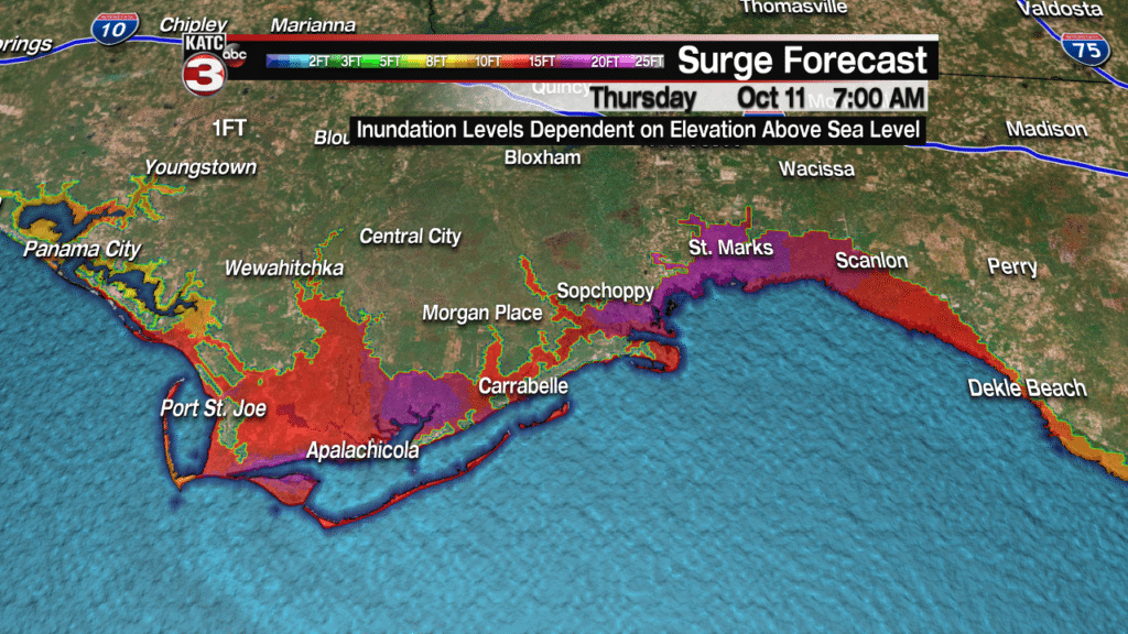
The winds may be relatively confined to the eye but that doesn’t mean that storm surge won’t be a major widespread problem especially along the Big Bend. That part of the coastline the continental shelf is long and shallow, the shape of the coastline itself also funnels water into this particular area. The two combined will lead to 15-20 ft worth of storm surge that could spread miles inland. As noted in the map above there are several rivers that flow into the Gulf in this region and those two will be under significant strain. A system this strong on this part of the coast is unprecedented, so we are approaching uncharted territory.
I’ll put out the same plea I did for Florence. This will be a disaster and resources will be stretched not just in the immediate aftermath but through the recovery period. They will need our help, just as we have needed theirs in the past. If you can I’d highly encourage anyone with the means to contribute to trusted relief efforts to do so and show that the Gulf Coast will always stand in solidarity with one another.
Video of conditions leading up to Hurricane Michael’s landfall can be viewed below:
