Weather Forecast Structure:
- Severe Weather Risk for Friday Evening
- Risks
- Timing
- 24 Hour Forecast
- Weekend Forecast
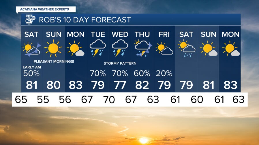
- 10-Day Forecast
SEVERE WEATHER RISK FOR FRIDAY EVENING
Our Northern-most Parishes are in an Enhanced (3/5) Risk, where as the rest of us in the yellow shaded region is in a Slight Risk (2/5).
Lets talk about threats associated with this.
RISKS:
We have the risk of:
Severe/Damaging Winds
Hail (lower end but decent support)
Isolated (low, but NON-Zero) Tornado Chance
Excessive Rainfall (Flash Flooding Potential)
I've included graphics that show what areas are at risk for each type of storm threat, including what that risk means in actual terms such as probability of certain size hail, etc. after the timing discussion.
TIMING:
Storms can get going anytime from now, most likely will begin anytime from 5-7 pm, and be on-going throughout the overnight.
Pinpointing the timing for your exact location with this type of storm is extremely hard to do.
Models are all resolving this a bit differently, my best guess is we see the worst of it between 8 pm and 3 am, and it will hopefully taper down from there. We'll see. That's why Rob and I are teaming up to watch the radar for you tonight.
As you can see, the GRAF and HRRR have totally different idea's of an outcome right now.


Lots going on with Crawfish Festival, Downtown Alive, Softball, etc. Have a way to receive your weather alerts!
Like the KATC Weather App.
Here are your areas of associated storm risks:


24-Hour Forecast

Weekend Forecast

10 Day Forecast