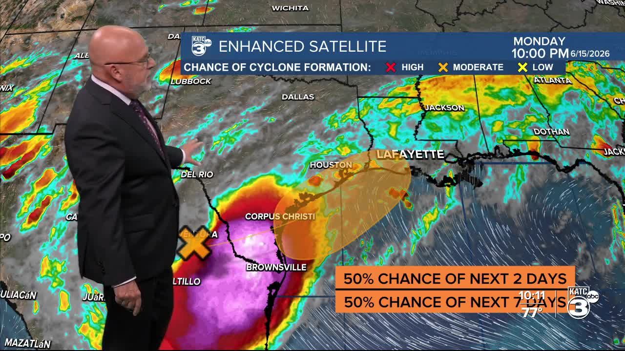


Periods of heavy rainfall and localized flooding will be possible for portions of Acadiana this week, with a medium chance by the National Hurricane Center that a tropical depression or storm may develop and impact portions of our area Wednesday and/or Thursday.
First and foremost this will be primarily heavy rain-maker event that will likely produce up to 5-10" of rain or more, primarily Tuesday through Thursday. Rainfall totals could be higher in isolated spots.
Initially heavier showers and storms Tuesday will be associated with a frontal trough sagging into our region igniting a high chance of scattered showers and locally heavy tropical thunderstorms.

Highest rainfall rates may approach 3-4" per hour, which could certainly lead to localized flash flooding.
By Wednesday the weak tropical disturbance along the Texas Coast may get back out over open water (or Gulf adjacent) affording a limited opportunity for development into a tropical depression or storm.
The National Hurricane Center upgraded the potential system to a medium chance of development through Thursday...near 50%.
If this system looks to become more organized over the next 24 hours a Tropical Storm Watch could be posted for portions of Acadiana and Louisiana on Tuesday...latest model guidance is showing that this may be less likely, but we'll see.

Per the NHC: "A trough of low pressure located over northeastern Mexico is producing a large area of disorganized showers and thunderstorms.
Development is not expected during the next day or so while the trough remains inland. However, the system could re-emerge over the northwestern Gulf of America late Tuesday or Wednesday, and environmental conditions there are marginally conducive for the formation of a short-lived tropical storm on Wednesday into Thursday.
Regardless of tropical cyclone formation, interests across southern and eastern Texas and portions of Louisiana and Mississippi should prepare for periods of intense rainfall over the next several days which could produce widespread, life-threatening flash, urban, and river flooding.
Gusty winds and coastal flooding are also possible along portions of the northwestern Gulf Coast, and Tropical Storm Watches or Warnings could be required on Tuesday."
Of course a Flood Watch is already in effect for all of Acadiana through Wednesday, with an extension into Friday quite possible.

Forecasting rain totals remains perplexing as if there development of a low in the Northwestern Gulf that could dramatically shift rain our rain totals but for now, the Weather Prediction Center rainfall accumulations over the next 5 days for Acadiana will be anywhere from roughly 4-8" with with isolated hots spots approaching the 10-15" range.

The Euro and GFS models support much the same for a base rainfall totals across the region, with the higher resolution GRAF Model showing the potential for more given the model shown here goes out to 7am Thursday.

The flood threat will likely continue beyond that as the WPC has most of Louisiana hatched in for a slight to in some cases a moderate risk of excessive rainfalls through Friday.

IF there's any tropical development, and that's a big "if", tropical storm-like conditions and winds may be found primarily along our coast along with increased tides.

Development or not, the tropical showers and storms may posses strong and gusty winds of 40-50 mph.
And finally to add insult to injury, if there's enough upper atmospheric spin with this system, isolated tornadoes may be possible with this system Tuesday through Thursday with the Storm Prediction Center having Acadiana hatched in for a "marginal risk".
The active weather pattern should abate later this weekend as high pressure moves in to knock the rain chances down and temperatures up into next week.
See the KATC 10 Day Forecast and Power Doppler 3 page for the latest, and stay apprised of our ever changing flood and tropical threats.
