


Another round of scattered showers and thunderstorms remains in the forecast for Acadiana into Friday evening, with more active weather this weekend...it'll quiet down next week.
In the near term, shower activity is expected to increase and expand in coverage with some thunderstorms developing into this evening, with activity tapering later tonight.
There is a marginal risk, level 1/5, for a few severe storms for the evening hours for northern portions of Acadiana on northward, with a few storms possibly capable of wind damage.

Per the Storm Prediction Center: "the strongest cells will pose a risk of water-loaded downdrafts and occasionally gusty/damaging wind."
After activity wanes tonight, look for another warm and very humid evening with lows near 80°.
Friday morning's low of 81° tied the record for the date, previously set in the "scorcher year" of 2023.
Plenty of clouds with scattered showers and storms remain in the forecast for our Saturday, holding our temperatures in the mid-80s, with the risk of storms possible continuing and refocusing in spots Sunday morning, per the GRAF model below:

Rain total accumulations per the HRRR and GRAF models are indicating 1-3" of rain possible for some through Saturday, with the GRAF on the higher end and more widespread in nature or the rains.
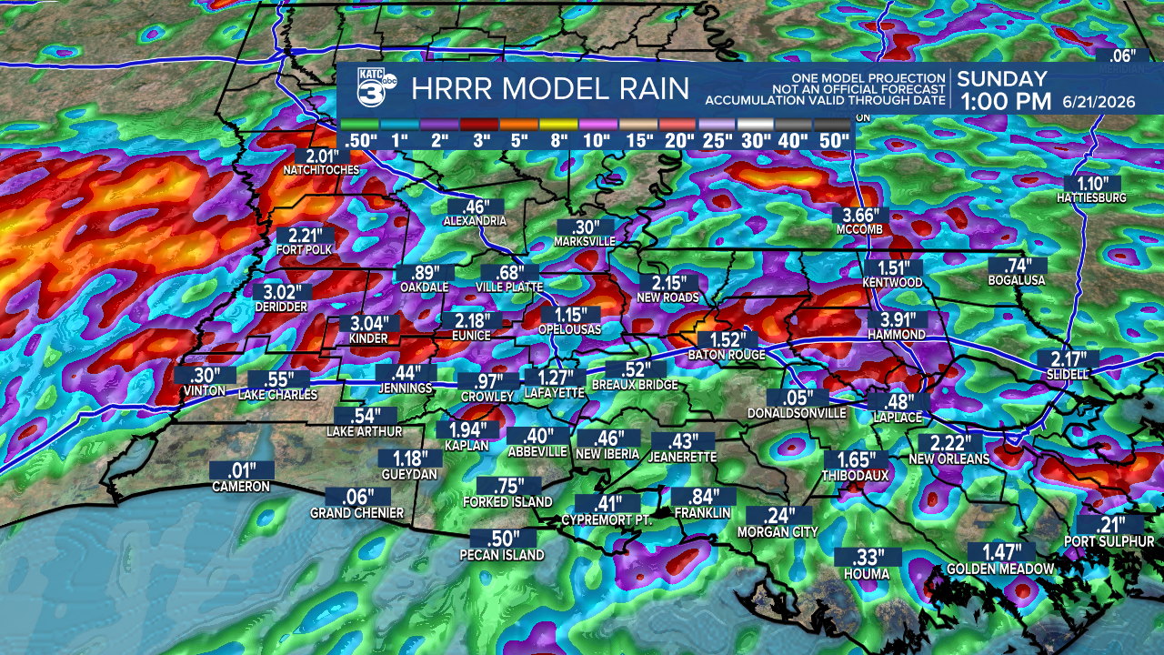
The GRAF is going for more potential storminess into Sunday morning, and is producing more staggering totals through Sunday.

We'll have to continue to monitor trends into this weekend and hope the GRAF just had an extra "excited" run...we'll see but localized flooding will be possible in some spots through the weekend.

It finally looks to settle down for Acadiana into next week with rain chances toning down with the heat and humidity amping up.
See the KATC 10 Day Forecast and Power Doppler 3 page for the latest.
Climatological Analysis of the catastrophic rainfall in Avoyelles Parish Thursday:
A ONCE IN A 1000 YEAR RAINFALL FOR AVOYELLES PARISH? The historical climate data says so.
Some nerdy perspective utilizing the Precipitation Frequency (PF) Estimates with 90% confidence Intervals from the NOAA Atlas 14, Volume 9, Version 2.
The NOAA Atlas 14 provides the official historical rainfall frequency estimates for most of the United States. It is heavily utilized by meteorologists, hydrologists, civil engineers, urban planners, and government agencies to design, build, and regulate infrastructure.
While we still await some verifiable rain gauge data, based off of the doppler estimates of 25-30" and a preliminary rain gauge reports of 23-24" in the area of Southern Avoyelles, this statement can be made confidently.
Given most of that fell in about 12 hours, with rainfall rates of up to 4" per hour at times, the rains that fell met the criteria of a 1000 year return period that averages 17.1", with a climatological range of 11.5-23.9" ...even if it fell in a 24 hour period at lower hourly rates!

Meaning, based on this atlas, a rainfall of this magnitude in this specific area would occur once every 1000 years!
This rainfall may may also break the all time Louisiana 24 hour rainfall record for the state of 24.40" held at the Sabine National Wildlife Refuge in Hackberry associated with a tropical depression in 1962! This is why we sweat the details of any tropical system and environment surrounding it, no matter the intensity, very seriously.
BTW Lafayette’s 24hr record is 19.63” with a slow moving hurricane on August 9, 1940...more than 30" fell in portions of Acadiana with that storm over a 3 day period.
Recent trends over the last couple of decades, including multiple 1000 year rainfalls reported on the Gulf Coast, Harvey and the Unnamed LA Storm of 2016 come to mind, are showing us that a warmer atmosphere holds more water, and that rainfall rates are getting higher, the frequency of these events are increasing, and tropical systems at our latitude are moving more slowly.
So this event was a chart-buster for sure, and the data from table below might very well be outdated given the multi-decadal trends of our warmer atmosphere and the subsequent bigger rainfall events that we see occurring. - Rob
