


Mostly cloudy, breezy and warm conditions Tuesday will precede our next weather-maker for Acadiana later Wednesday, accompanied by another risk of severe storms into Wednesday evening.
In the near term, expect mostly cloudy skies with temperatures and dew points holding near the lower 70s.
Some patchy fog may be possible by daybreak but a south breeze at 5-10 mph should keep any thick stuff at bay.
Tuesday will be mostly cloudy and warm and should get to breezy into the afternoon. Highs will reach the lower 80s with perhaps a few intervals of afternoon sun.
Look for southerly winds near 10-15 mph with some gusts to 20-25 mph into the afternoon.
Rain chances should remain near 10% or less Tuesday.
The risk of showers and storms will begin to increase into the latter part of Wednesday as an upper low near the Southwestern U.S. moves eastward and eventually spawns weak surface low pressure across Texas Wednesday.

This system and it's upper level support will likely ignite showers and thunderstorms across the region into the latter part of Wednesday (60-70%) with highest rain chances for Acadiana (90%) looking to arrive into Wednesday evening/night.

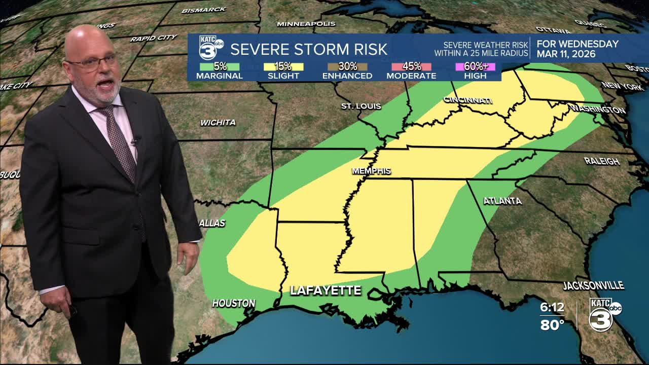
The Storm Prediction Center (SPC) has Acadiana and Louisiana highlighted for the risk of severe storms into Wednesday, and for Acadiana, it looks to be during the evening/early nighttime hours.

The northern part of Acadiana is hatched in for a slight risk, a level 2/5, while roughly south of the Highway 190 corridor is in a marginal risk, a level 1/5.
The primary threat will be damaging winds, but hail and an isolated tornado cannot be ruled out.
The SPC forecast intensity coverage and refinement will be likely as we get closer to Wednesday.
Another 1-2" may be possible with the next round of storms Wednesday night.
After the storms, it will cool off significantly later this week with lows dropping into the 50s and then 40s for a couple of nights with highs holding in the 60s Thursday, but rebounding into the 70s Friday.
The weekend looks spring-like, but another front arrives late next Sunday or into Monday followed by another chill that will last for several days.
See the KATC 10 Day Forecast for the latest numbers.
This weekend's rains:

Looking back at some of this weekend's impressive rain totals, primarily for the northern Acadiana parishes with 6-8" plus in spots putting an end to burn bans in the region.
