


The coolest air of the season is on the way to Acadiana with temperatures similar to what we may experience in early December while a catastrophic hurricane is raking Jamaica and on to Cuba later tonight.
In the near term, a cold front will likely spark scattered showers and thunderstorms for Acadiana this Tuesday evening with prime-time for activity mainly between 7 and 10pm.

The Storm Prediction Center has increased the odds of a few severe storms for Southwest Louisiana and portions of Acadiana for activity that could produce isolated damaging winds and hail, perhaps, an isolated tornado.

As of late this afternoon, a Tornado Watch was issued for the northwestern parishes of Acadiana through 10pm...but the watch may not last that long here.

Storms move in just after sunset and end from east to west through roughly 10-11pm...the highest rain chances for Lafayette looks to be around 8pm give or take an hour.
Overall storm dynamics look to be weakening as activity crosses Acadiana, but we'll nonetheless keep an eye on it.

Behind the front, it's full frontal fall with highs Wednesday and Thursday holding only in the mid-60s and dropping into the mid-40s tomorrow night/Thursday morning and then again Thursday night into Friday morning.


And there will be a wind chill factor through Wednesday with winds gusting in the 30-35 mph range later tonight through tomorrow. A Wind Advisory is in effect for Acadiana.

Look for sunny skies for our Halloween with highs moderating to near 70° while trick or treat temperatures will be in the lower 60s dropping into the mid-upper 50s.
Thereafter, there looks to be a another quick-moving front that may generate a few showers Saturday night, but this system may just give us a glancing blow, with most precipitation missing us to the west and/or south.
The weather next week promises we stay entrenched in a fall pattern with highs mostly in the low-mid 70s while low moderate closer tot he lower 50s...still below normal for this time of year!
See the KATC 10 Day Forecast.
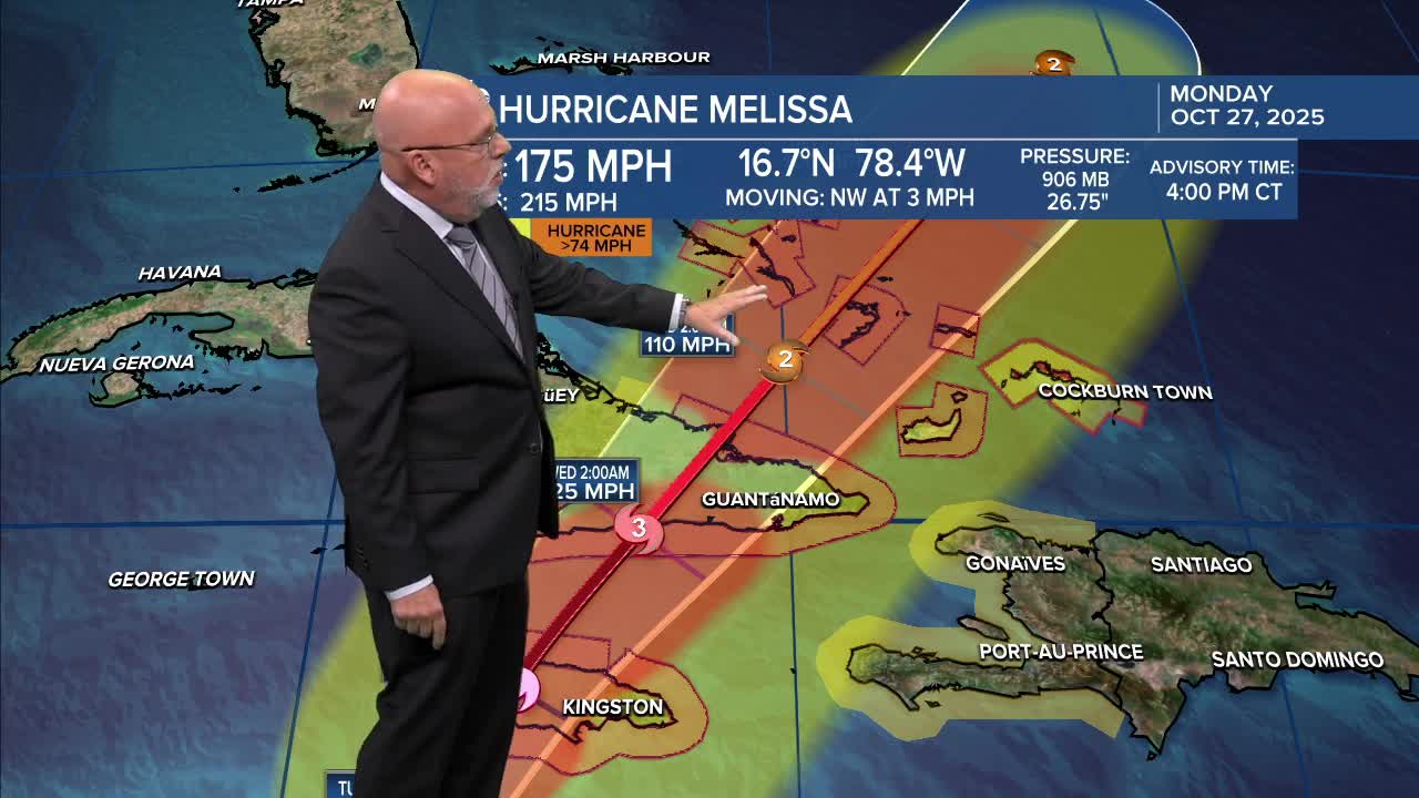
Meanwhile in the tropics, Category 5 Hurricane Melissa made a historical and catastrophic landfall on the Western Part of Jamaica today with 185 mph sustained winds and a pressure lower than that of Katrina at it's most intense at 892 mb at landfall.

Melissa is the strongest storm to make landfall on record in the Western Hemisphere...
Melissa has moved back out into the ocean north of Jamaica and has weakened to a Category 4 storm, with the storm impacting Cuba overnight and the Bahamas Wednesday, and near Bermuda as it accelerates by Thursday night.
