


Acadiana will see milder temperatures along with increasing rain chances starting Wednesday, with an unsettled pattern, and eventually colder conditions accompanied by rain, some possibly frozen this weekend.
In the near term, after one more chilly night tonight, Acadiana will be on a warming trend with a mostly sunny Tuesday.

Shower activity returns Wednesday as a disturbance arrives accompanying what will be a persistent sub-tropical jet stream overhead.

With these features in place, expect a cloudy and unsettled Thursday with a continued chance of shower activity.

As the the sub-tropical jet remains overhead Friday into the weekend cloudy skies will persist with a very shallow but very cold front sliding into our region late Saturday.
A disturbance in the sub-tropical jet will produce a rainy conditions during the day Saturday followed by sharply colder conditions Saturday night.
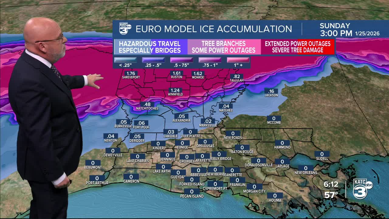
There could be a low end risk (right now in the 10-20% range) of the rain turning briefly over to freezing rain for portions of Acadiana late Saturday night, ending Sunday morning.

This will be a significant disruptive winter storm from Texas to the Mid-Atlantic, with most of the winter action most likely north of Acadiana.

The atmosphere will be set-up for warmer air aloft with a saturated layer producing the precipitation Saturday into Saturday night, ending Sunday morning.
And with eventually near freezing temperatures down near the surface, spells freezing rain and some sleet primarily for Northern Louisiana, but the GFS brings colder air and the freezing rain potential farther southward into Central Louisiana and toward Acadiana.

For now, we're not going with any significant ice accumulations in Acadiana, but stay tuned for possible changes as we are on the margin of significant icing that may miss us by less than 100 miles to the north...we'll see if temperatures get cold enough Saturday evening while the precipitation field stays in place. Timing will be everything.

While the Euro has been the superior deterministic model over the last few years, we can't discount the GFS given the magnitude and breadth of cold Canadian air that will be invading the U.S. later this week...it performed well for the blizzard nearly one year ago.
For now most we will lean mostly to cold rains for Acadiana, but as we know the forecast will likely change and morph as the week wears on...so stay tuned.
And forget about significant snow at this point, as the best chance of the white stuff will probably be a state away...but we cannot rule out an isolated snow flurry toward Sunday morning...depending on how it all works out.
Meanwhile, what's much more certain, is the coldest temperatures of our winter season are coming for this weekend and should continue into the week that follows.
See the KATC 10 Day Forecast for the latest.

In space weather news today:
Per NOAA's Space Weather Prediction Center: "an S4 severe solar radiation storm is now in progress - this is the largest solar radiation storm in over 20 years. The last time S4 levels were observed was in October, 2003. Potential effects are mainly limited to space launch, aviation, and satellite operations."

Expect a great aurora show later tonight across the Northern U.S. wherever skies are clear with another possible view/glow on the northern horizon perhaps reaching the portions of the South.

Too difficult to say whether we'll get to see the aurora locally in Acadiana, but similar conditions to the last few events could be likely...plus, we should have clear skies..fingers crossed but no promises!
