


Avoyelles Parish remained in a Flood Emergency Thursday afternoon after 25-28" of rain fell last night and today; conditions will be getting hotter area-wide, along with some storms sticking around.

While the remnants of Tropical Storm Arthur brought some tropical rains to Acadiana Wednesday night into Thursday, it was much worse for portions of Central Louisiana and Southwestern Mississippi where catastrophic flooding rains have fallen.

Evacuations and water rescues were ongoing in Avoyelles where more than 25 inches of rain has fallen between Bunkie, Mansura, Simmesport, Hessmer, Plaucheville, Cottonport and Morrow per doppler estimates, mostly in the last 12-18 hours.
Reports via the NWS included an ambulance that was swept into a creek near Mansura, but the driver was safe. While the Moreauville Fire Department was reporting over 100 homes that are flooded just in their district. Some of them have never flooded before.
Also so far: 25 homes flooded in Plaucheville, 40 homes in Simmesport, 15 in Hessmer, 15 in Cottonport...numbers here are expected to increase.

To top it off, there was also a tornado (of unknown intensity at this time) that was spotted near Dupont in Avoyelles Parish roughly before noon Thursday.
Moving forward, fewer storms hotter temperatures, and high humidity will bring back summer conditions to Acadiana into the weekend, with still the risk of scattered showers and thunderstorms.

Activity looks to be more likely into Friday evening and then again during the day, maybe evening too for Saturday...thereafter, rain chances decrease to a more summer-like 10-30% from Sunday through much of next week.
Unfortunately, for Central Louisiana, and perhaps as far south as our northern Acadiana parishes, it continues to look rather active thunderstorm-wise, with more locally heavy rains possible into the weekend per the GRAF Model below:

More typical summer heat and more typical rain chances will return to our area by late this weekend and likely stay for a while...
And thanks to temperatures near the lower 90s and dew points flirting with 80°, a Heat Advisory is in effect for all of Acadiana Friday.
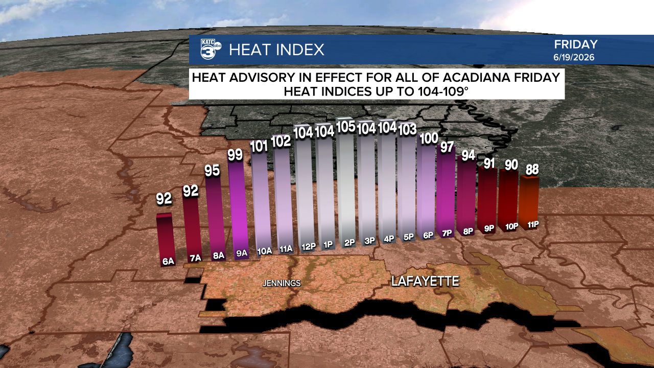
Heat indices should reach 104-109° during the height afternoon heating.
See the KATC 10 Day Forecast and Power Doppler 3 page for the latest.
