
Per the Storm Prediction Center and local National Weather Service, the tentative count associated with the late Halloween storm system were of at least 173 wind damage reports in the region, and up to 19 tornadoes as of Thursday evening…fifteen of which were indicated in Louisiana.

The National Weather Service storm surveys were still underway, but locally tornadic damage was primarily reported in the Calcasieu, Beauregard, Grant and Rapides Parishes, and in Washington Parish in extreme Eastern Louisiana.

At least 13 of the 15 tornadoes reported and survey were of EF1 or EF2 intensity.
The tornadoes in Calcasieu Parish near Lake Charles were considered EF1 tornadoes, with up to 86 to 110 mph winds.
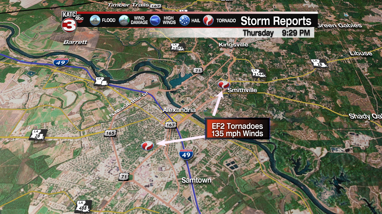
At least 5 tornadoes were reported in Rapides Parish ranking either EF1 or EF2, with the damage in the Alexandria area ranking as high end EF2 tornadoes with 135 mph winds.
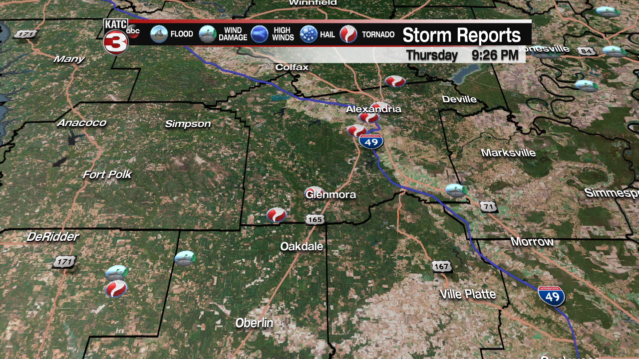
All totaled, there were ten tornadoes reported in the surrounding Acadiana region from Lake Charles to Alexandria north into Grand Parish.
Outside of the more major reports of damage, a few downed trees, tree limbs, and sporadic power outages were reported locally across Acadiana, and luckily just 1-3″ of rain fell across the area.

More details on the preliminary storm Storm Prediction Center reports can be found here, while the latest NWS storm survey from the Alexandria can be found here.
The full National Weather Service Lake Charles Text Reports are below:
000
NOUS44 KLCH 020129
PNSLCH
LAZ028-031-021330-

PUBLIC INFORMATION STATEMENT
NATIONAL WEATHER SERVICE LAKE CHARLES LA
829 PM CDT THU NOV 1 2018

...NWS DAMAGE SURVEY FOR 10/31/18 TORNADO EVENT...

ALEXANDRIA/PINEVILLE/BALL TORNADO...

RATING:                   EF-2
ESTIMATED PEAK WIND:      135 MPH
PATH LENGTH /STATUTE/:    17.9 MILES
PATH WIDTH /MAXIMUM/:     500 YARDS
FATALITIES:               0
INJURIES:                 0

START DATE:               OCT 31 2018
START TIME:               1118 PM CDT
START LOCATION:           5 N WOODWORTH/RAPIDES/LA
*START LAT/LON:           31.2256/-92.4983

END DATE:                 OCT 31 2018
END TIME:                 1151 PM CDT
END LOCATION:             4 NE BALL/RAPIDES/LA
END_LAT/LON:              31.4499/-92.3461

SURVEY SUMMARY: A STRONG TORNADO STARTED NEAR HWY 165 SOUTH OF ALEXANDRIA, WHERE
TREES WERE SNAPPED ALONG THE WEST SIDE OF THE HIGHWAY. THE STORM CROSSED HWY 165
AND HIT NEAR THE HORSESHOE DRIVE REGION, WHERE SEVERAL MORE TREES FELL, INCLUDING
SOME ON HOMES. THE STORM REMOVED THE ROOF OF A RESTAURANT ON MACARTHUR DRIVE,
AND SEVERAL OTHER BUSINESSES HAD ROOF DAMAGE AS WELL. BEHIND THE MALL, A BOWLING
ALLEY HAD A WALL COLLAPSE. SIGNIFICANT ROOF DAMAGE OCCURRED TO SEVERAL BUSINESSES
IN THE LEE STREET/OVERTON STREET REGION. THE TORNADO CROSSED THE RED RIVER, AND
MOVED FROM THE SOUTH SIDE OF HIGHWAY 167 TO THE NORTH SIDE OF HIGHWAY 167 IN
PINEVILLE. NUMEROUS TREES AND POWER LINES WERE DOWNED ON THE CAMPUS OF LOUISIANA
COLLEGE AND SURROUNDING AREAS. SOME OF THESE TREES DID LAND ON HOMES AND VEHICLES.
AS THE TORNADO CONTINUED NORTH-NORTHEAST, IT SNAPPED MORE TREES AND POWER LINES
IN THE KINGSVILLE REGION, INCLUDING DONAHUE FERRY ROAD, PEARCE ROAD, PINECREST,
AND CAMP BEAUREGARD. EAST OF THE BALL-PARADISE REGION, MANY LARGE TREES WERE
DOWNED ALONG WASHBOARD ROAD, DAMAGING SOME HOMES AND BUILDINGS. THIS TORNADO
CONTINUED INTO GRANT PARISH. FOR MORE INFORMATION ON WHAT HAPPENED IN GRANT PARISH,
LOOK FOR THE NWS SHREVEPORT PNS PRODUCT.

BUNDICK LAKE TORNADO...

RATING:                   EF-1
ESTIMATED PEAK WIND:      105 MPH
PATH LENGTH /STATUTE/:    10.1 MILES
PATH WIDTH /MAXIMUM/:     500 YARDS
FATALITIES:               0
INJURIES:                 0

START DATE:               OCT 31 2018
START TIME:               1143 PM CDT
START LOCATION:           4 NW DRY CREEK/BEAUREGARD/LA
START LAT/LON:            30.7091/-93.1008

END DATE:                 OCT 31 2018
END TIME:                 1153 PM CDT
END LOCATION:             3 NW MITTIE/ALLEN/LA
END_LAT/LON:              30.7481/-92.9378

SURVEY SUMMARY: A TORNADO FORMED SOUTH OF BUNDICK LAKE ALONG HWY 394, SNAPPING
TREES AND POWER LINES. IT CONTINUED NORTHEAST, SNAPPING MORE TREES AND POWER
LINES ALONG HWY 1147, HWY 113, AND BLANCHARD ROAD. NUMEROUS TREES AND POWER
LINES WERE DOWNED ON HIGHWAY 26 ON THE ALLEN PARISH SIDE, CAUSING THE HIGHWAY
TO BE CLOSED TEMPORARILY.

GLENMORA TORNADO #1...

RATING:                   EF-1
ESTIMATED PEAK WIND:      105 MPH
PATH LENGTH /STATUTE/:    9.6 MILES
PATH WIDTH /MAXIMUM/:     300 YARDS
FATALITIES:               0
INJURIES:                 0

START DATE:               NOV 01 2018
START TIME:               1210 AM CDT
START LOCATION:           10 SW GLENMORA/RAPIDES/LA
START LAT/LON:            30.9198/-92.7315

END DATE:                 NOV 01 2018
END TIME:                 1221 AM CDT
END LOCATION:             2 W GLENMORA/RAPIDES/LA
END_LAT/LON:              30.9998/-92.6014

SURVEY SUMMARY: A RURAL TORNADO BEGAN NEAR HWY 462, MOVING EAST-NORTHEAST.
SEVERAL TREES WERE BLOWN DOWN OR SNAPPED ALONG EAST RIVER ROAD AND ASHMORE ROAD.

GLENMORA TORNADO #2...

RATING:                   EF-1
ESTIMATED PEAK WIND:      105 MPH
PATH LENGTH /STATUTE/:    3.3 MILES
PATH WIDTH /MAXIMUM/:     600 YARDS
FATALITIES:               0
INJURIES:                 0

START DATE:               NOV 01 2018
START TIME:               1222 AM CDT
START LOCATION:           3 NW GLENMORA/RAPIDES/LA
START LAT/LON:            30.9883/-92.6279

END DATE:                 NOV 01 2018
END TIME:                 1225 AM CDT
END LOCATION:             2 N GLENMORA/RAPIDES/LA
END_LAT/LON:              31.0063/-92.5756

SURVEY SUMMARY: ANOTHER RURAL TORNADO FORMED NEAR GLENMORA, MOVING NORTHEAST.
NUMEROUS TREES AND POWER LINES WERE DOWNED ALONG HWY 113.

SURVEY SUMMARY: A TORNADO FORMED SOUTH OF BUNDICK LAKE ALONG HWY 394, SNAPPING
TREES AND POWER LINES. IT CONTINUED NORTHEAST, SNAPPING MORE TREES AND POWER
LINES ALONG HWY 1147, HWY 113, AND BLANCHARD ROAD. NUMEROUS TREES AND POWER
LINES WERE DOWNED ON HIGHWAY 26 ON THE ALLEN PARISH SIDE, CAUSING THE HIGHWAY
TO BE CLOSED TEMPORARILY.

EF SCALE:  THE ENHANCED FUJITA SCALE CLASSIFIES TORNADOES INTO
THE FOLLOWING CATEGORIES.

EF0...WEAK......65 TO 85 MPH
EF1...WEAK......86 TO 110 MPH
EF2...STRONG....111 TO 135 MPH
EF3...STRONG....136 TO 165 MPH
EF4...VIOLENT...166 TO 200 MPH
EF5...VIOLENT...>200 MPH

NOTE:
THE INFORMATION IN THIS STATEMENT IS PRELIMINARY AND SUBJECT TO
CHANGE PENDING FINAL REVIEW OF THE EVENTS AND PUBLICATION IN NWS
STORM DATA.

$$

ERICKSON/JONES
Public Information Statement
National Weather Service Lake Charles LA
918 PM CDT Thu Nov 1 2018
…NWS Damage Survey For 10/31/18 Tornado Event
Evadale Tornado…
Rating: EF-1
Estimated Peak Wind: 107 MPH
Path length /Statute/: 2.2 Miles
Path width /Maximum/: 189 Yards
Fatalities: 0
Injuries: 0
Start date: Oct 31 2018
Start time: 747 PM CDT
Start location: 2 W Evadale/Hardin/TX
Start Lat/Lon: 30.3585/-94.0958
End date: Oct 31 2018
End time: 755 PM CDT
End location: 1 NE Evadale/Jasper/TX
End_lat/lon: 30.3621/-94.0611
Survey Summary: Tornado started just west of the Neches river and moved east for a time just north of HWY 96. The tornado moved slightly northeast damaging several roofs of homes and blowing out the walls of a metal building. Several trees were also snapped along the path. The tornado crossed HWY 96 north of Evadale and ended near county road 847.
Buna Tornado #1…
Rating: EF-0
Estimated Peak Wind: 75 MPH
Path length /Statute/: 0.7 Miles
Path width /Maximum/: 150 Yards
Fatalities: 0
Injuries: 0
Start date: Oct 31 2018
Start time: 801 PM CDT
Start location: 2 SSW Buna/Jasper/TX
Start Lat/Lon: 30.4032/-93.9711
End date: Oct 31 2018
End time: 803 PM CDT
End location: 2 S Buna/Jasper/TX
End_lat/lon: 30.4044/-93.9600
Survey Summary: A weak tornado briefly touched down south of Buna along county road 784 producing minor
tree damage.
Buna Tornado #2…
Rating: EF-1
Estimated Peak Wind: 104 MPH
Path length /Statute/: 8.6 Miles
Path width /Maximum/: 260 Yards
Fatalities: 0
Injuries: 0
Start date: Oct 31 2018
Start time: 810 PM CDT
Start location: 3 E Buna/Jasper/TX
Start Lat/Lon: 30.4303/-93.9111
End date: Oct 31 2018
End time: 822 PM CDT
End location: 11 ENE Buna/Newton/TX
End_lat/lon: 30.5159/-93.8079
Survey Summary: Tornado started along FM 253 causing roof damage to one home. The tornado then moved through a remote area causing tree damage for several miles to the northeast before ending near HWY 87.
Carlyss Tornado…
Rating: EF-1
Estimated Peak Wind: 109 MPH
Path length /Statute/: 6.44 Miles
Path width /Maximum/: 900 Yards
Fatalities: 0
Injuries: 0
Start date: Oct 31 2018
Start time: 1150 PM CDT
Start location: 6 SW Carlyss/Calcasieu/LA
Start Lat/Lon: 30.1411/-93.4728
End date: Nov 01 2018
End time: 1200 AM CDT
End location: 1 SSE Carlyss/Calcasieu/LA
End_lat/lon: 30.1506/-93.3647
Survey Summary: Tornado near Shelby Lane north of HWY 108. The tornado continued east northeast for several miles crossing Choupique road, Thompson road, and Johnny Jones roads before ending around HWY 27. Damage was mostly caused by snapped trees, however a few roofs were torn off and with several RV’s overturned and metal sheds blown over.
Lake Charles Tornado…
Rating: EF-1
Estimated Peak Wind: 107 MPH
Path length /Statute/: 0.6 Miles
Path width /Maximum/: 126 Yards
Fatalities: 0
Injuries: 0
Start date: Nov 01 2018
Start time: 1215 AM CDT
Start location: 4 SSW Lake Charles/Calcasieu/LA
Start Lat/Lon: 30.1755/-93.2231
End date: Nov 01 2018
End time: 1217 AM CDT
End location: 3 S Lake Charles/Calcasieu/ LA
End_lat/lon: 30.1750/-93.2144
Survey Summary: A brief tornado touched down just south of the MCNeese university causing damage to trees, roofs and carports. The old Kroger store also sustained damage.
EF Scale: The Enhanced Fujita Scale Classifies Tornadoes into
the following categories.
EF0…Weak……65 to 85 MPH
EF1…Weak……86 to 110 MPH
EF2…Strong….111 to 135 MPH
EF3…Strong….136 to 165 MPH
EF4…Violent…166 To 200 MPH
EF5…Violent…>200 MPH
Prien Area Wind Damage…
Peak wind Estimated: 80 MPH
Path length /Statute/: 5.0 Miles
Path width /Maximum/: 5800 Yards
Fatalities: 0
Injuries: 0
Start date: Nov 1 2018
Start time: 1210 AM CDT
Start location: Lake Charles/LA
Start Lat/Lon: 30.1823/-93.2734
End date: Nov 1 2018
End time: 1215 AM CDT
End location: Lake Charles/LA
End_lat/lon: 30.1608/-93.2131
Survey Summary: A large area of damaging winds occurred over south Lake Charles. Causing sporadic damage between I-210 and Gauthier Road.
Other information…
An additional tornado likely occurred between HWY 171 and Bundick lake. However, an NWS storm survey has not yet been completed in this area. Details on this event will be available once the survey is completed.
Note: The information in this statement is preliminary and subject to change pending final review of the events and publication in NWS Storm Data.
