Monday afternoon drier air in the mid to upper levels has limited shower activity across Acadiana allowing for a fair amount of sunshine warming temperatures into the upper 80s.
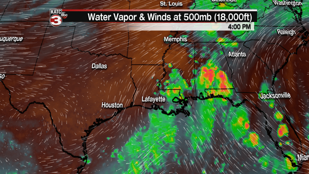
Now with this sunshine heating the moist ground a couple isolated showers can not be ruled out later today.
Tuesday we still have the southerly flow off the Gulf pushing tropical moisture over Acadiana which could produce about a 50% chance for hit or miss showers and storms to fire up throughout the day.
Here is a look at the RPM model showing the projected radar for Tuesday.
I think the model might be over doing it a little bit but I would still have the rain gear handy just in case the model turns out correct.
Wednesday looks to be the best chance for widespread showers and storms for Acadiana as a frontal boundary will be working down into the region.
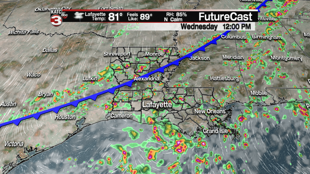
There is still a little uncertainty on how far this front slides down into Acadiana.
Right now I think it will make its way down to about the I-10 corridor before then lifting back up to the north on Thursday.
If this plays out it will create another decent chance for scattered showers and storms on Thursday as the boundary is still in the region.
By Friday our weather pattern will return to a typical summer pattern with warm and humid conditions giving way to a 50% chance for hit or miss showers and storms during the afternoon but these should fade around sunset meaning Friday Night Football should not have any real issues.
For the weekend it looks like rain chances will be going down to about 30-40% but that means we will have more sunshine heating highs into the upper 80s to near 90.
And even it to the first week of October temperatures look to remain above average in the upper 80s with no real cool down in the extended forecast.
- – – – – – – – – – – – – – – – – – – – – – – – – – – –
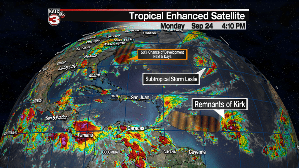
Out in the Atlantic we just have Subtropical Storm Leslie but the National Hurricane Center is watching a few other disturbances with medium chances of becoming tropical systems this week.
Right now Subtropical Storm Leslie continues to be a fairly unorganized system with winds of 40 mph.

There is a chance late Monday or Tuesday Leslie could develop tropical characteristics and use its sub title but the hurricane center expects this system to stay way out to sea and weaken back to a subtropical low Wednesday.
After Wednesday the center now projects Leslie to loop back around and merge with a new system which could develop as part of a frontal boundary moving out into the north Atlantic.
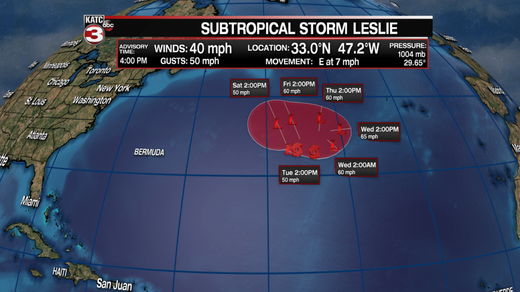
Most world models are picking up on this front and associated low merging with Leslie and have it developing into a tropical system and could become Michael by the end of the week.
In the southern Atlantic the remnants of Tropical Depression Kirk are still producing a decent cluster of showers and thunderstorms.
The hurricane center is giving these showers and storms a 50% chance of redeveloping into a tropical system in the coming days but by this weekend the disturbance will likely fizzle out as it runs into the strong wind shear in the Caribbean.
Finally, the center is watching an area of showers and thunderstorms a couple hundred miles off the East Coast.
This disturbance has a 50% of development as it rides up along the Carolina and Virginia beach this week but most models have it remaining fairly unorganized but it could still produce heavy showers for coastal areas which is bad news for North and South Carolina as many rivers are still extremely high causing devastating flooding from Florence.


