You will feel the humidity in the air as soon as you set outside and that extra moisture has already produced a round of scattered showers over Iberia, St. Martin and St. Mary parishes this morning.
These showers are beginning to dissipate but later this afternoon with the daytime heating that will get another round of scattered showers and storms to fire up throughout Acadiana.


A few storms could produce brief periods of heavy downpours, lots of lightning and gusty winds up to 30-40 mph.
When it is not raining this afternoon it will be another hot and humid day with highs in the lower 90s and heat indices near triple digits.
If you have outdoor plans this weekend or plan on heading out to the Delcambre Shrimp Festival make sure you keep an eye on the sky as we will have a 40-50% chance for scattered showers and storms each afternoon.
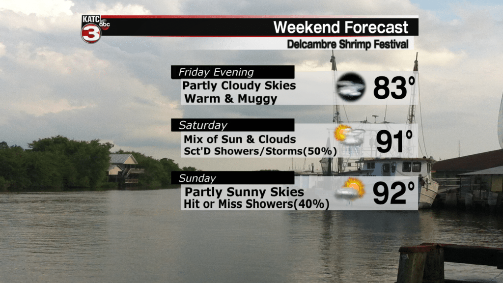
The good news is neither day looks to be a wash out and the showers/storms that do develop should only last about 30-45 minutes.

Like today those communities that do not get any rain this weekend it will still feel very summer-like with highs in the low 90s and feel like temperatures above the century mark.
The unsettled weather pattern will continue into the first half of next week meaning more rain chances Monday and Tuesday.
Tuesday afternoon/evening into Wednesday morning looks to be the best chance for widespread showers and storms in Acadiana as a cool front works its way down over the region.
Behind this front we might finally get some refreshing dry air to slide down into Acadiana for the second half of the work week helping to make it feel more comfortable during the afternoon and allow overnight lows to drop down into the upper 60 to lower 70s.
In the Atlantic Tropical Storm Ernesto is holding together with winds of 45 mph and gusts up to 60 mph.
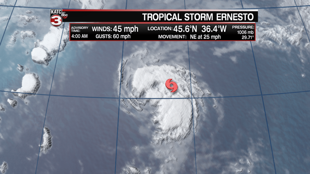
Ernesto is now racing off to the NE at 25 mph and will begin to move over cooler waters causing the system to lose its tropical characteristics by Friday evening.
![]()
This weekend the post tropical low could end up affecting Ireland with heavy rains and tropical storm force winds.
Also in the tropics the wave near the Windward Islands has already shown signs of weakening and only has a 20% chance of development in the next 5 days.

However, this wave could still bring heavy showers and storms to the lower Lesser Antilles Islands this weekend.
