Acadiana can expect a stormy start to the weekend, with the threat of severe storms early Saturday, followed by a taste of mid-winter-like temperatures, under full sunshine Sunday.
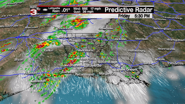
A strong cold front will likely produce an eastward moving line of showers and thunderstorms across the area, primarily during the morning through very early afternoon hours, with the threat of some severe storms possible.
The Storm Prediction Center has most of Acadiana hatched in for a "slight" risk of severe storms, a level 2 out of 5, with Lower St Martin and St Mary Parishes delineated for an "enhanced" (3 out of 5) risk of severe storms.

An enhanced risk of storms means there will be up to a 30% chance of a storm containing damaging winds, isolated, perhaps strong tornadoes, and large hail within a 25 mile radius of any point in the enhanced area.
The latest model guidance suggest that a squall line will develop over the western part of the state during the predawn hours advancing eastward and intensifying especially after daybreak.
The thunderstorm energy potential and helicity, or tornado potential show upticks in their values, especially from Lafayette/Vermilion Parishes on eastward.
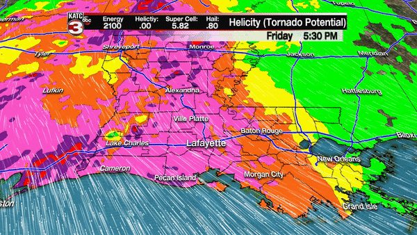 Helicity factors speed shear, or how much wind speed increases with height and cyclonic updraft rotation. This means that any isolated discrete or "loner" cells that may develop ahead of the squall line could produce a tornado…which is right in line with the "enhanced" risk of severe storms from Lower St Martin and St Mary Parishes eastward through all of Eastern Louisiana.
The threat of severe weather and storms should end quickly early tomorrow afternoon, with cloudy skies accompanied by temperatures holding mostly in the 60s, possibly clearing just in time for sunset.
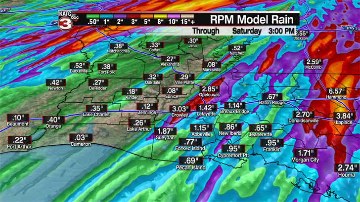
 The storms, while developing over Acadiana, should be progressive with generally 1-2" or less expected, but a few spots may see up to 3" in isolated areas. The threat of heavier rains of up to 3-5", with possible flooding, should occur east of Acadiana, into Eastern Louisiana.
Skies will certainly clear Saturday night with breezy and sharply cooler conditions likely through Sunday morning.
Temperatures Sunday morning will drop into the mid-40s with wind chills likely threatening the upper 30s in a few spots.
Full sunshine, breezy and cool conditions are expected Sunday with highs only reaching the low-mid 60s, which would be perfectly normal for January!
After a very chilly start Monday morning in the upper 30s to lower 40s, look for a nice warm-up to near 70 for an afternoon high.
Much of next week’s weather looks quite nice with a gradual warming trend through Wednesday.
More clouds but quiet conditions are possible later next week.
Our next front, and good chance of storms, looks to arrive next Saturday night, but as always the forecast beyond a week out is always subject to change.
