

Acadiana got very lucky Monday morning as winter precipitation moved across the area.
Most of us had braced for rounds of intense freezing rain leading to ice accumulation of up to a half inch, stressing the infrastructure and turning roads into ice rinks.
The roads are still icy, and there was plenty of winter precipitation but we avoided the worst accumulation and a big part of the reason was sleet.
Instead of driving rain freezing on contact most of the rain was already in the process of freezing, making it slushy outside but not necessarily a think icy glaze.
If your wondering how we squeezed out a more frozen type of precipitation the answer sits several kilometers up in the atmosphere.
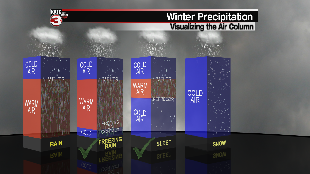
First let's get into how you get the different types of winter precipitation, which is mostly based off temperatures through the atmosphere.
Snow and rain are fairly simple, for rain the entire column of air is more or less above freezing allowing liquid rain to fall, for snow it's the opposite the whole column is below freezing and the precipitation comes down as snow.
The other two, freezing rain and sleet, are little more complicated.
In order to get both of them you need a layer of warm air sandwiched between cold air up high and cold air at the surface, and the depth of the warm air dictates sleet or freezing rain.
The deeper layer of warm air gives the precipitation less time to refreeze so it arrives as rain but is so cold it freezes on contact, sleet has less warm air so it's in the process of refreezing into snow again when it arrives.

Sunday night while profiling the temperatures in the atmosphere there was a deep layer warm air and a shallow layer that dropped below the freezing line which would be a classic profile for freezing rain.
This lead to the more intense forecasts calling for freezing rain and strains on infrastructure.

The profile taken this morning was much different.
At the last moment we got to cool down the atmosphere in the warm layer which sunk it back below freezing.
This gave precipitation more time to refreeze as it came down which in turn meant heavier sleet and less freezing rain Monday.
This goes to show how small the changes can be to see the impacts change drastically from one forecast to the next, and for Acadiana this was a good thing.
------------------------------------------------------------
Stay in touch with us anytime, anywhere.
To reach the newsroom or report a typo/correction, click HERE.
Sign up for newsletters emailed to your inbox. Select from these options: Breaking News, Evening News Headlines, Latest COVID-19 Headlines, Morning News Headlines, Special Offers
