


Update to earlier story:

Fred is now a tropical depression, this was expected and the remainder of the forecast remains unchanged.
-----------------------------------------------------------------------------------------------------------------
Acadiana's forecast rolls along with high heat and high humidity through the rest of the work week.
Helping out with that heat will be a push of more moisture in the area resulting in a wider scattering of showers and storms in the afternoon.
There's not severe weather or overly problematic rainfall expected, but do be on the look out for frequent lightning and some gusty winds.
Showers will remain fairly scattered across the area through the weekend, and the moisture doesn't look to abate at all next week.
This of course all remains dependent on the tropics and the influence that a tropical storm will have in the eastern Gulf of Mexico.
Tropical Update:
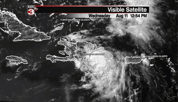
Tropical Storm Fred remains the main concern in the weather world as it approaches the Hispaniola coast, and a very important time period for the development of the forecast.
The reason this window of time is so important is because the structure and placement of Fred's center when it emerges from the island is going to determine how strong and exactly where the storm ends up.
As of Wednesday afternoon there are two different possibilities that could potentially play out, and while there's not much consensus and there's plenty of uncertainty there is model support for both of the options.
National Hurricane Center forecasters seem to be hedging their bets a little and have the storm going down the middle of both solutions, which at this time is the right call, but the edges of the cone do indicate the potential spread in outcomes.
Notice that over the next 24 hours Fred will return to a tropical depression, but will likely start strengthening again into a tropical storm by early Friday morning as it escapes the major influences of land.
Depending on how Fred looks after its encounter with Hispaniola there's a chance it will have to rebuild all of its structure back from scratch, something it will attempt to do while battling back a little shear.
This is the outcome posed by the GFS which weakens Fred the most put pulls it more into the eastern Gulf and along the western edge of Florida into the Florida Panhandle.
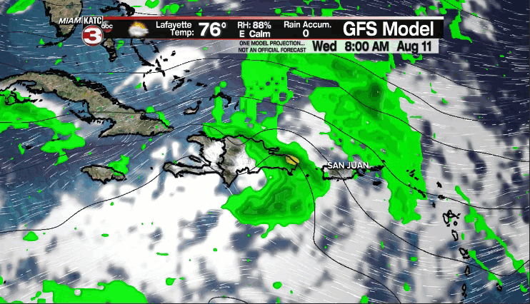
The GFS has consistently been the weaker of the two scenarios, and the one that the NHC is putting a little more stock in as the center of the cone closely follows that of the GFS; although the GFS may be under doing intensity a little.
If this is ultimately going to be the scenario that plays out look for the center of the storm to remain a little closer to the Dominican Republic and for the storm to struggle to gain much strength through the end of the week.
Despite looking like it was trending toward the GFS solution on Tuesday the EURO model remains further to the north and east with a stronger storm impacting south Florida.
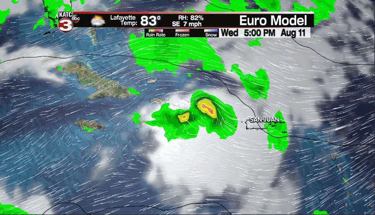
The Euro still washes out the storm over the islands but has it reform a center a little further north than the GFS does, and as a result favors a stronger storm moving further east into Florida over the weekend.
Obviously the two different scenarios bring dramatically different impacts to the Sunshine State so monitoring the trends once it emerges from Hispaniola will be key in figuring out which scenario ultimately pans out.
Either way it remains out of Louisiana and in the eastern Gulf of Mexico.

East of Fred is another wave that is taking a similar path and is showing signs of becoming tropical over the next several days.
This is another one to monitor as models are picking up on it, but there's a lot of uncertainty with this one so we won't dive too deep into it just yet.
Just keep it in mind that it is out there and to check in on it from time to time.
------------------------------------------------------------
Stay in touch with us anytime, anywhere.
To reach the newsroom or report a typo/correction, click HERE.
Sign up for newsletters emailed to your inbox. Select from these options: Breaking News, Evening News Headlines, Latest COVID-19 Headlines, Morning News Headlines, Special Offers
