

It has been a rough night for both Tropical Depression 13 and 14, with the structure of both storms looking a little more broken up early Friday morning then it did the night before, but this doesn't mean much in the grand scheme.
Both of these storms are expected to strengthen over the coming days, but the poor structure is pointed out because it makes the forecast for these systems that much more difficult.
While confidence is higher then it was 24 hours ago there's still a decent amount of uncertainty in the forecast, particularly when it comes to intensity (which is always a tough call in the best of circumstances).
The reason I think it's good to start a discussion with that is simply a reminder to keep in mind the difficulty in forecasting and to be prepared to see change in the forecast especially as it evolves over the weekend.
That being said, both systems pose a potential threat to Acadiana and the impacts from Tropical Depression 14 could arrive as early as Monday as landfall looks likely early next work week close to the Texas/Louisiana border.
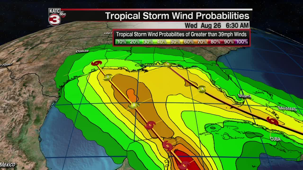
So let's start with a look at Tropical Depression 14, as of the 7:00 a.m. bulletin not much has changed, the National Hurricane Center continues to forecast a Category 1 hurricane arriving early Tuesday morning in southwest Louisiana.
Winds remain at 35 mph, with gusts around 45 mph and it's currently moving to the WNW at 12 mph and expected to strengthen into a Tropical Storm by Friday afternoon (likely making it Laura), and possibly even a hurricane by the time it reaches the Yucatan Peninsula.
As mentioned earlier the structure of the storm doesn't look as impressive as it did Thursday which is making it a trickier forecast to sort through and it will make the hurricane hunter data all the more important.
Despite a ragged look early Friday morning the expectation is that the storm will strengthen before landfall along the Yucatan, this landfall will be important to watch because it will determine how strong the storm will be when it gets into the Gulf of Mexico.
The latest suite of models, with both the GFS and EURO coming into fairly decent agreement early Friday is that the storm once in the Gulf will strengthen slowly and both keep it more on the line of a strong tropical storm as it makes landfall with rain spread far to the east.
The previous runs though showed a stronger system moving inland so right now will wait for a little more consistency before making any major changes to the intensity forecast.
Once we get a better feeling for the intensity forecast we'll be able to nail down some of the specific impacts for Acadiana, but currently there's just too many question marks, add on top of that the fact that this storm will be interacting with another storm in the eastern Gulf of Mexico.
That other storm of course is Tropical Depression 13, winds currently are sustained around 35 mph, gusts up to 45 mph, and the storm is moving to the WNW at 21 mph.
Again the National Hurricane Center has shied away from major changes to the track waiting to see a little more from the various model outputs which seem to drop the storm a little further south and interacting with a lot of the land.
That track would obviously have major implication in the ultimate outcome of this storm, as the current forecast track features a fairly clean approach to the eastern Gulf of Mexico as a Category 1 storm.
Once again the problem here is structure with the convective bursts occurring in two different regions of the systems which may indicate less of a center and more of an open wave, hurricane hunters will investigate today to see what may be causing this.
If a new center has formed then that will shift where the models are latching on to initiate the storm and would cause some fairly big changes in both track and intensity, so that hurricane hunter data as always is very important.
Those who follow along with model runs both the EURO and GFS seem less then impressed with the storm, and don't have any major intensification and instead have it more an open wave as opposed to a tropical storm.
Again, it can't really be stated enough, there is not a lot of consistency with the models right now so that may be a throw away run, or it could be the start of a trend only time will tell.
As we sit on Friday morning the chance that we get tropical storm type weather in Acadiana is about 50-60% but those number will change as we get closer to a potential landfall, but the odds are that we end up seeing something from this system.
That means that while the weather is quiet Friday and Saturday it would be a good idea to review your hurricane plan and start going through some of the early preparations so there's no scramble on Monday.
Unfortunately this uncertainty means that our window to prepare can change and if things speed up that could collapse the window significantly so use the quiet weather this weekend to your advantage by starting to go review and implement your plan.
The last couple of years have been examples of just how fast things can change in the Gulf of Mexico both in terms of storms falling apart or going through very intense rapid intensification, so make sure that you're staying informed.
This forecast should not be the final verdict and with the lack of overall confidence change is almost inevitable so keep up to date with the forecast.
We will obviously have any updates for you and will work to keep you all informed, and as always the best thing to be is prepared, not panicked.
------------------------------------------------------------
Stay in touch with us anytime, anywhere.
To reach the newsroom or report a typo/correction, click HERE.
Download our free app for Apple, Android, Roku and Amazon devices.
Sign up for newsletters emailed to your inbox. Select from these options: Breaking News, Evening News Headlines, Latest COVID-19 Headlines, Morning News Headlines, Special Offers
