


A Flood Watch was hoisted for Acadiana by the National Weather Service (NWS) Friday in anticipation of a continuation of our active and wet weather pattern through the entire weekend.

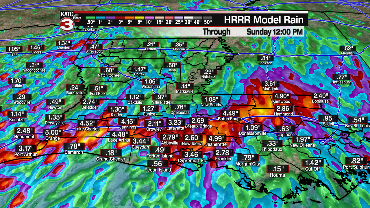
The NWS is indicating that an additional of 2-5" of rain accumulations will be possible, with isolated areas possibly seeing more on either Saturday or Sunday.
Our grounds remain so saturated that anything more than a 2" rainfall over a period of 1-2 hour will likely cause at the very least, some localized street flooding.
As in the last few days, showers and storms should be scattered in nature, but precipitation periods are expected to be lasting a little longer.
In this type of pattern, thunderstorms clusters dominate the short-term forecast horizon (not our models or forecasters), so timing of best storm chances remains nearly impossible.

Overall the thinking is that after a break in the action Friday afternoon, the atmosphere will slowly recharge during the evening and overnight hours with the chance of showers and storms increasing as the night wears on.
Rain chances are set at 70% overnight but will likely rise into the 90% range by early Saturday.
The best bet for wet conditions appears to be from Saturday morning through the mid-latter part of the afternoon with activity expected to stabilize toward Saturday evening.
Little change is anticipated in the pattern Sunday with high daytime rain chances likely to stay in the 80% range...give or take 10-20%.
Our latest model data continues to indicate much the same with rain totals ranging from 1-5" through the next 48 hours...but as always in this pattern, isolated much higher amounts can be possible where storms tend to be more persistent.
The guarded better news today is that the models are now indicating that ever so slightly drier and more stable conditions will begin to work their way into the Acadiana area next week, resulting in a slow and gradual lowering of rain chances deeper into the week.

This will mean our below normal temperatures of late will gradually trend back to normal for the time of year with highs getting back into the mid-upper 80s mid-late in the week and perhaps into the following weekend...it will remain quite humid though with overnight lows getting above normal, in the low-mid 70s.
See the KATC 10 Day Forecast for the latest.
The tropics for now remain quiet and are expected to stay that way for a better part of a week.
However, long range outlooks beyond 10 days, do show very deep tropical moisture surging toward the Gulf of Mexico into the 3rd week of the month...of course this is mostly conjecture, but it is indeed getting to be that time of year.
------------------------------------------------------------
Stay in touch with us anytime, anywhere.
To reach the newsroom or report a typo/correction, click HERE.
Sign up for newsletters emailed to your inbox. Select from these options: Breaking News, Evening News Headlines, Latest COVID-19 Headlines, Morning News Headlines, Special Offers
