


It is shaping up to be a very wet weekend with growing confidence in the tropical forecast as models slowly start to converge on something resembling consensus.
There's still some nuance to the forecast and a few specific timing and impact issues that remain to emerge but we're getting a much better idea of the overall picture this Wednesday morning.
The disturbed area in the Bay of Campeche hasn't moved much and isn't expected to until Thursday and once it does we'll see it start to develop into a tropical system, possibly getting a name.
Currently the NHC has the chance for further development into a tropical system at about 60% over two days, and 90% by the end of the week.

It will be important not to get hung up on the "tropical storm vs tropical depression" discussion as the impacts for either are largely going to be the same, and that's heavy showers and possible flooding this weekend.
As mentioned above there's still a few issues with regards to timing but, it seems safe to say, that showers will get started on Friday afternoon and continue through the weekend with the bulk of the showers arriving on Saturday.
Winds will be gusty but won't be anything extreme so we aren't anticipating any widespread power outages, although steady southerly winds will force the tides to run much higher than normal.
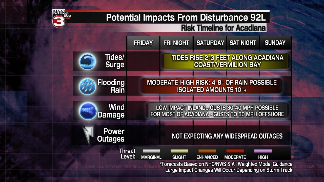
The GFS and EURO are both in alignment in bringing the center of the storm on shore along the Sabine Pass, but with the dry air to the west it will force all the impacts well to the east of the center, which means heavy rain for Acadiana.
It remains unclear, and likely will until we start to see the showers set up, exactly where the heaviest rain is going to occur but no matter where you are be prepared for 4-8" of rain from Friday through Sunday (isolated areas pushing 10-12").
The bulk of the rain is expected to arrive on Saturday which is when we'll have the highest threat for flooding, although after a very soggy day a few heft downpours may push some areas over the edge on Sunday.
Flash flooding is going to be the biggest issue with this system, most of the rivers have returned to normal levels after May's heavy rain, but it would still be a good idea to avoid low lying areas and local waterways.
Avoid travel this weekend and be prepared to spend most of the weekend at home and off the road, if you live in a flood prone area make sure that you closely monitor the radar this weekend.
There's still going to be tweaks and changes to the forecast so make sure that you're staying on top of everything and keeping up to date with any changes by staying tuned to KATC both on air and online.
------------------------------------------------------------
Stay in touch with us anytime, anywhere.
To reach the newsroom or report a typo/correction, click HERE.
Sign up for newsletters emailed to your inbox. Select from these options: Breaking News, Evening News Headlines, Latest COVID-19 Headlines, Morning News Headlines, Special Offers
