


Those who were hoping for a clearer picture regarding next week's round of winter will be disappointed as model runs are still having a hard time coming together, and seem to be changing from run to run.
There seems to be growing consensus that some abnormally cold temperatures are on the way, with models agreeing that Tuesday morning seems to be the coldest, but that's where those agreements come to an end.
We still have plenty of time to see these models come together and build a little consensus, and once Thursday's front passes those models will have one less thing to factor in and should start to come together.
As they do come together it will be interesting to see which model changes more drastically and by comparing these changes we can get an idea which one has a better handle of the situation.
In the meantime we can go through the various scenarios being suggested by the two major models and I'll give an idea of what we'll be watching for over the coming days.
Keep in mind that the following model runs are just projections, they help in creating a forecast but they aren't the forecast themselves, and even more importantly these are the model runs that are valid for Wednesday morning. (It's entirely possible that things look different by Wednesday afternoon.)
Let's start with the more mild solution which is the EURO model which seems to be backing off some of the extreme cold and the chance for winter precipitation, settling instead on a shorter round of cold weather and cold rain.

The EURO is coming in considerably warmer Wednesday morning and doesn't seem to think the extreme cold air will be able to push far enough south, meaning it's banking on the front stalling a little further north than originally thought.
That's not to say that the EURO is warm, it still is projecting temperatures in the 20s on Tuesday morning, and the cold outbreak in this solution seems to be more short lived again indicating the front will move further north quicker.
Even the wind chill values seem slightly more mild than the GFS, and again they'll be very cold for parts of the forecast but they're about 20 degrees warmer than the aforementioned GFS.

There's still some strong signaling for wet weather to start next work week, from both models, but it should come as no surprise that the warmer EURO is less impressed with the chance for frozen precipitation.
It still leaves the door open for the northern tier of Acadiana to pick up a little freezing rain on Monday, but the boundary between cold and freezing rain would be draped across the area.
This would be the nightmare scenario, for the forecaster, as the diving lines between the two are often very sharp an almost impossible to predict the exact location.
It should be pointed out though that this is how the EURO started behaving for the last projected event, a slow lifting of the winter precipitation until we were just left with cold rain so that will be a trend to monitor.

The GFS is a much more extreme solution both in temperatures and the onset of frozen precipitation to start next week.
Immediately what jumps out is just how intense the cold outbreak is with temperature dropping to border line single digits on Tuesday morning (the corresponding wind chill would be sub-zero).
It's not just the intensity of the outbreak though but also the longevity of it with temperatures getting into the 20s as early as Sunday and highs struggling to get out of the 30s for several days and staying that way through most of next week.

Similar to the EURO the GFS has the onset of precipitation on Monday afternoon as a front moves through the area, but since it has the colder temperatures in place it is much more bullish on the possibility of sleet/freezing rain.
Ice accumulation in this scenario is likely since we would have had a very cold weekend which would mean that the ground isn't warm enough to help prevent freezing at the surface.
If we do see freezing rain you don't need me to tell you it could have major impacts on travel across Acadiana and could potentially be a pretty disruptive event.
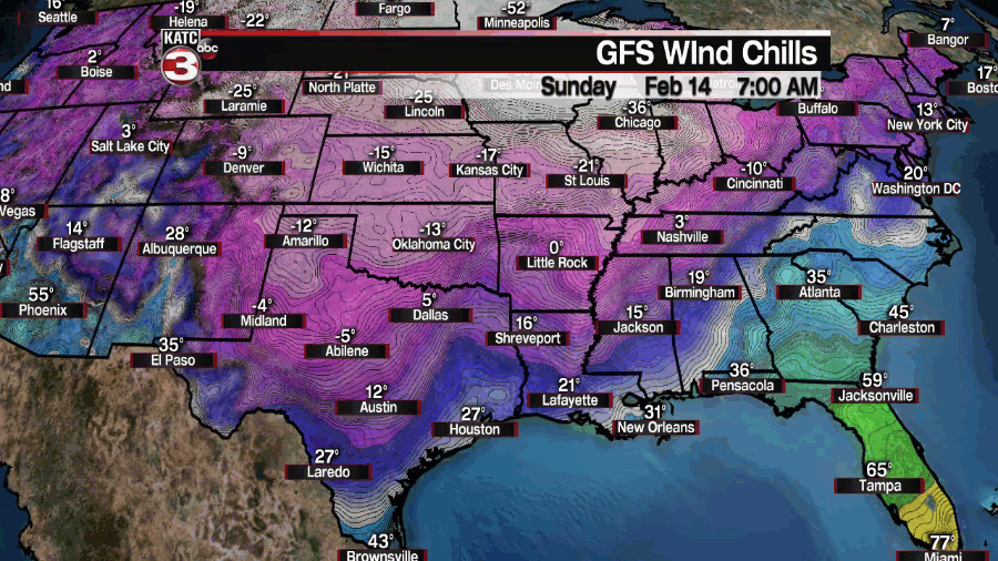
The ice would be problematic and disruptive when it comes to travel but the wind chill values projected would be down right dangerous, multiple morning with wind chill values in the teens and bottoming out below zero on Tuesday.
Again the intensity of the event is one thing but the longevity is what would be the most concerning aspect of the GFS solution.
The truth is that ultimate outcome is going to fall somewhere in between while it can't be discounted the GFS seems a little too extreme but there's enough signals in the models producing a major cold outbreak that the EURO seems too mild.
While it may seem like they're miles away there are some useful similarities that we can use to make a few determinations.
The first of which is both seem to indicate that the coldest morning will be Mardi Gras, the intensity of the cold is drastically different, but both produce probably the coldest morning of the year on Tuesday.
A wet Monday is the other thing that both models seem to agree with which means that at the very least we're getting some very cold rain, again exactly how cold remains to be seen, but it's good to see some kind of agreement from our two most trustworthy models.
This is what we should look for over the coming days, which model trends to the other. Does the GFS warm up or does the EURO cool down, or maybe they meet in the middle?
We're getting into the part of the forecast process where watching trends is very important, now that we've seen consistent signatures for something we can start figuring out what that something is.
It goes without saying that the next two days of the forecast process will tell us a lot about what to expect come next week.
------------------------------------------------------------
Stay in touch with us anytime, anywhere.
To reach the newsroom or report a typo/correction, click HERE.
Sign up for newsletters emailed to your inbox. Select from these options: Breaking News, Evening News Headlines, Latest COVID-19 Headlines, Morning News Headlines, Special Offers
