

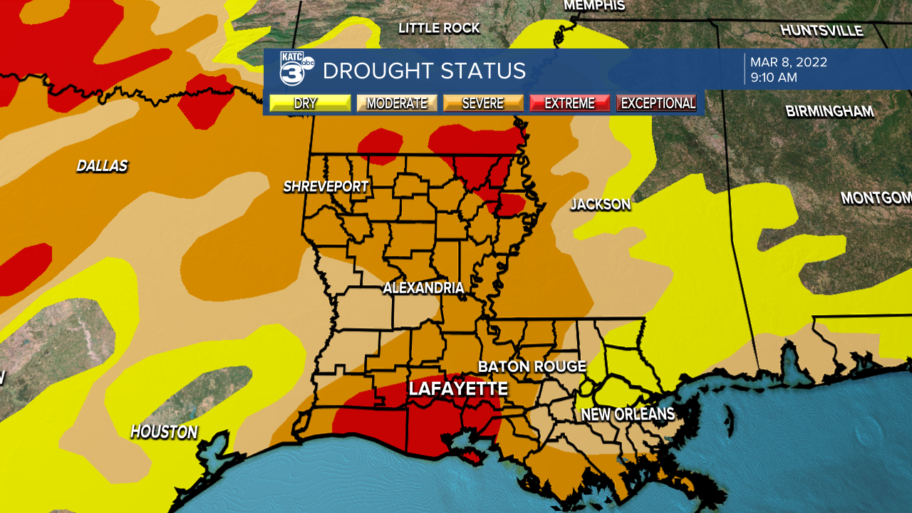
Drought leads to drought, and quietly Acadiana has found itself in the middle of a pretty serious drought.
While there's certainly a deep irony in writing an article about drought during a pretty wet day, I felt like it was a good idea to lay out some of the numbers and examine how we got here.
Since January 1st, Lafayette has only received 3.76" worth of rain, which is just over 7" below what our annual average should be for this same time period (these numbers do not include the expect rainfall on Tuesday, March 8th).
That's only for the this year, it doesn't include the fall of 2021, which is when this dry pattern started with below average rain totals for August, October, November and December. (September ended up being a very wet month courtesy of a couple really heavy rainmakers).
Since August, Lafayette has been about 10.37" below average which would include a very wet September; but since the proverbial faucet shut off in October Lafayette is now well over a foot below average.
The first dry month, August, passed with little notice.
In fact it was heavily celebrated because at the time we were coming off what had been an exceptionally wet period and were discussing the actual possibility of 100" of rain for the year.
August was followed by another very wet month and while the 100" talk had subsided but the general conversation was still about how wet the year had been, then the rain more or less ended.
October through December all ended very dry and through that time period Lafayette was 6.61" of rain below what would usually be produced during that time period.
Despite a solid quarter of the year being considered dry, 2021 still ended as the 6th wettest year on record, so even in the middle of dry spell the overall conversation was about how wet the year had been.
So quietly, while we were all still marveling at how wet the spring and summer had been, Acadiana had entered a drought.
The big question now is when and how do we get out of it?
While the answer to the latter is simply "more rain" the first question is significantly harder to answer.

Acadiana is entering one of the driest periods of the year, so already this isn't necessarily a particularly wet time and our rainy season doesn't start to pick up until around May.
So simply based off typical pattern it looks as if the drought is going to persist, and the CPC (Climate Prediction Center) believes that drought conditions will persist for southern portions of Acadiana.
North Acadiana and north Louisiana may see drought persist but under slightly improved conditions, a few solid rounds of rain could go a long way in parts of the state.
Looking at anomaly data for the next few weeks there's hard to see any particular pattern, while the GFS has us staying drier than normal, the EURO is the complete opposite hinting at a wetter pattern.
Figuring out when we're going to exit a drought requires a crystal ball, and unfortunately we don't have one of those handy here in the weather lab.
The impacts from a drought can be severe, especially one that is as deep as the one that has taken hold of Acadiana.
Already a burn ban has been issued for the state because of dry conditions, and the longer we go without rain the larger the impacts will be especially for agriculture.
Some of the driest areas in the state are also some of our biggest producers of agriculture with major rice, soybean, and sugarcane fields all falling under the level 3 drought.
A lack of falling freshwater to replenish an aquifer, not only does that strain supply but also allows a creep in of salt water intrusion which would make the water that is there unusable.
Any kind of influx of saltwater in southern parts of the aquifer could have an impact on crops grown in the coastal parishes.

Drying conditions will also increase the likelihood of wildfires, especially in areas that are still dealing with a lot of dead, dry vegetation after back to back generational hurricanes in 2020 and 2021.
These are not just areas that were considered the "hardest hit areas" either, but all the downed trees in the central and northern parts of the state from Laura, Delta, and Ida would all be possible fuel for a wildfire.
There is actually ongoing examples of this in Bay County, Florida which was hit hard by Hurricane Michael in 2018, and is now faced with major wildfires forcing the evacuation of some residents.
Droughts in Louisiana are different than the mega droughts out west, they're never as severe or as prolonged so it's impossible to compare the two, so don't think that because we aren't looking at scorched, cracked Earth that we aren't experiencing a serious drought.
There's still going to be rain, this is south Louisiana after all, but it will take more than a downpour or two to break us out of the cycle we find ourselves in currently.
The showers we get on Tuesday aren't going to break the drought by any stretch, even when coupled with the expected rain on Friday, but every little bit helps.
In the meantime it won't be a bad idea to be a little more cognizant of water usage and realize, while it's never great to waste water, doing so now could be particularly egregious.
------------------------------------------------------------
Stay in touch with us anytime, anywhere.
To reach the newsroom or report a typo/correction, click HERE.
Sign up for newsletters emailed to your inbox. Select from these options: Breaking News, Evening News Headlines, Latest COVID-19 Headlines, Morning News Headlines, Special Offers
