Another upper disturbance will cruise eastward today, helping a weak surface low to move across the northern Gulf of Mexico. This has already brought the cloudiness back into the region, but rains will certainly follow, especially into the afternoon and evening hours.
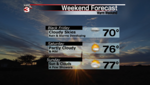
As of now, it appears there will be widespread rains over the Gulf of Mexico, with more scattered rains over land. A few thunderstorms are possible later this afternoon, and into the evening hours. Rainfall totals are expected to be around 1/4 inch with higher amounts possible along the coast and in the offshore waters. Temperatures are expected to climb into the upper 60s to near 70 degrees. Winds will return out of the southeast.
As the disturbance races eastward, rainfall will taper off this evening, and skies will become partly cloudy. Overnight temperatures will run in the mid 50s. Expect a mix of sun and clouds with highs in the lower to middle 70s on Saturday. Little if any rain is expected. Looking ahead to Sunday, another quick moving disturbance and a cold front will bring a few scattered showers and possibly a thundershower. Highs Sunday should reach the mid 70s again. Early next week will be chilly with highs back in the 50s and lows in the 30s.


