As of 4PM Sunday the National Hurricane Center has upgraded the tropical wave near the Bahamas and Cuba to Potential Tropical Cyclone 7.
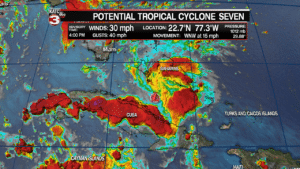
Right now the potential tropical cyclone is producing a relatively unorganized area of showers and thunderstorms but is starting to show signs of circulation forming with winds of 30 mph.
According the the track from the National Hurricane Center they have the system could become a tropical storm Monday afternoon as it pass over the Florida Keys.
If it becomes a tropical storm it will get the name Gordon.
The storm will then quickly race through the eastern Gulf on Tuesday while gradually strengthen as it heads for the mouth of the Mississippi River making landfall sometime late Tuesday night or early Wednesday morning.
![]()
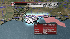
Tropical Storm watches have been issued for areas along the Gulf Coast from the Alabama-Florida line to Morgan City as they could experience minor coastal flooding of 2-5 feet and sustained winds of 40-60 mph.
Once making landfall the storm will head WNW towards Alexandria and then Shreveport as it weakens to a tropical depression.
![]()
Good news is the models continue to show the system as a a fairly small storm with the worst of the rain and winds on the eastern side of the storm so New Orleans and the Mississippi Coast could see the heaviest rains and winds.
Locally in Acadiana I think we might just see scattered showers and storms on Wednesday and Thursday and maybe some breezy conditions but no major issues expected.
For a complete look at the models and what I think we might expect check out my earlier article here:
With the latest advisory at 1PM on Sunday the National Hurricane Center has up the chances for tropical development in the Gulf to 90% in the next 5 days.

Right now the hurricane center is watching a tropical wave located between the Bahamas and Cuba producing a relatively unorganized area of showers and thunderstorms.

The wave is continuing to encounter unfavorable upper level winds the next couple days preventing the system from getting too organized but we are beginning to see a little bit of rotation trying to form.
In the next 48 hours the wave is projected to remain just a tropical wave as it heads for south Florida where it could produce heavy rains for Miami, Fort Lauderdale and Fort Myers on Labor Day.
Late Monday afternoon/evening the wave will move out into the Eastern Gulf where it will encounter less upper level winds allowing for the system to get better organized.
The models are now coming into agreement the the potential system will quickly move through the Gulf and head for an area between the Mississippi Coast and Grand Isle.


The good news with the system moving pretty quickly across the Gulf it will have less time to really develop so most models have back down on the potential intensity of the system, with most projecting it will only strengthen to a tropical depression or maybe a weak tropical storm.
If it would become a tropical storm it would get the name Gordon.
As for impacts this looks to be a pretty small storm with the worst weather on the right side.
So, heaviest rains look to be for the New Orleans and Mississippi Coast where they could see 2-4 inches of rain.
With the system only expected be a tropical depression or tropical storm winds should not be too much of a factor as they will be around 30-40 mph with gusts up to 50 mph, however they could still knock down a few dead trees or limbs, especially with the ground so wet from all the rain we are getting today and tomorrow.
After making landfall the models project the system will head north into northern Louisiana or Mississippi.
So for Acadiana we look to stay on the western side of the system, which is the drier side, thus most models are showing us only getting scattered showers and storms on Wednesday and Thursday.


That said the system is still a few days out and the track and intensity could change so keep it with KATC for the latest on this potential tropical system.
