

LAFAYETTE PARISH — If you're wondering how a forecast with just a 40% chance of rain turned into six inches of water on the ground before sunrise, you're not alone.
Around 2 a.m. thunderstorms formed over Acadiana and then didn’t move. By 7 a.m. the official gauge at the Lafayette Regional Airport had already measured 6.34 inches of rainfall, with rates exceeding 2 inches per hour. That’s a pace fast enough to overwhelm even well-designed infrastructure and drainage systems. But let's break down why this happened and what the forecast really meant.
What a 40% chance of rain actually means
One of the most common weather misconceptions I hear is about how we communicate rain chances. When I say there's a 40% chance of rain, it doesn't mean there’s a 40 out of 100 chance it’ll rain where you are. It actually means there's a 40% chance that any point in the forecast area will receive measurable rainfall.
So on days like today, while most of the area might stay dry, a small section can still get hit hard, as Lafayette and other parts of Acadiana did. Also, that 40% has nothing to do with how much rain will fall. A low chance doesn’t mean low intensity. You can have a 20% chance of a storm and still get several inches of rain if you're in the unlucky zone where it hits.

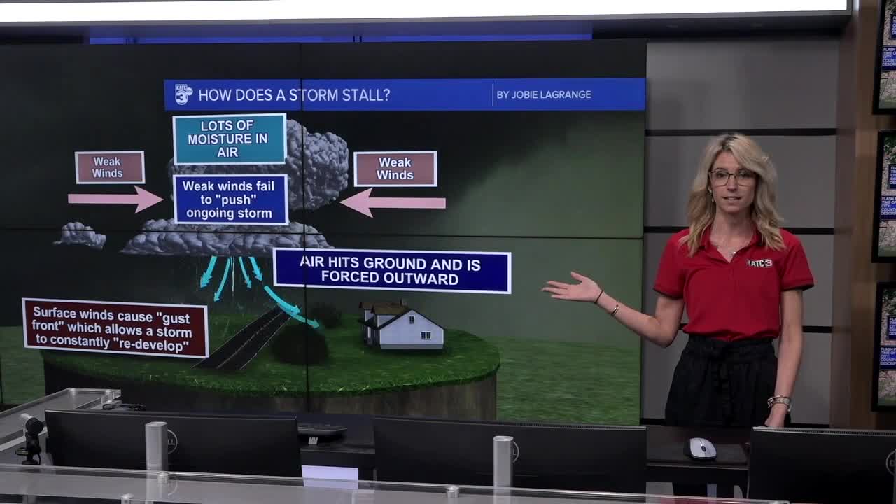
How storms stall and why that’s dangerous
The other hard to predict aspect this morning wasn’t just rain, it was stalling. Here’s what happened:
- High moisture in the air: Southerly winds were pumping deep tropical moisture into Acadiana.
- Weak upper-level winds: There wasn’t enough wind higher in the atmosphere to move the storms along.
- Gust fronts recycling moisture: As rain-cooled air sank and hit the ground, it spread out and lifted more warm, humid air back into the same storm. That’s called a gust front, and it helped the storms regenerate in place.
- Self-sustaining feedback: This loop kept going for hours, creating what’s called a training effect—where storm cells keep moving over the same area like train cars on a track.
It’s a recipe for flash flooding, and it’s one of the harder things to predict in real time.

The limits of forecasting models
Even with our best tools, pinpointing storms like these is tough. High-resolution forecast models can “see” features down to about 1–3 square kilometers, but that’s still larger than many storm cells, which can be just 10 to 15 miles wide. That means models might see the potential for storms, but they can’t say exactly where they’ll form or stall.
And here’s another challenge: these models only update once an hour. That means when conditions shift rapidly, like they did this morning, there’s a lag before we can see it reflected in the data.
Even the WPC did not have us in an area expected to receive Excessive Rainfall, there are only so many tools available.

What you can do
Events like this are reminders that it’s not just about whether rain is likely, it’s about being prepared for what kind of rain we’re talking about. If you see terms like "localized heavy rain" or "training storms," pay attention. Even a small chance can bring big problems.
Stay weather-aware by checking for real-time alerts, not just the morning forecast. And if your area is flood-prone, always have a plan. What happened in Lafayette today could happen anywhere in Acadiana given the right conditions. Download the KATC Weather App to stay informed and follow our team of Meteorologists on social media for an extra way to receive real time weather updates.
